
Topografische kaart Golog
Interactieve kaart
Klik op de kaart om de hoogte weer te geven.
Over deze kaart
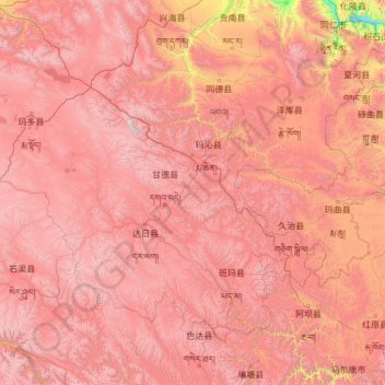
Naam: Topografische kaart Golog, hoogte, reliëf.
Locatie: Golog, Qinghai, China (32.52460 96.93497 35.62120 101.77730)
Gemiddelde hoogte: 4.177 m
Minimale hoogte: 2.568 m
Maximale hoogte: 6.039 m
The lay of the land of the prefecture is largely determined by the Amne Machin mountain range (max elevation 6,282 m), which runs in the general northwest- to-southeast direction across the entire prefecture, and beyond. The existence of the ridge results in one of the great bends of the Yellow River, which first flows for several hundreds of kilometers toward the east and southeast along through the entire Golog Prefecture, along the southern side of the Amne Machin Range, until it reaches the borders of Gansu and Sichuan; it and then turns almost 180 degrees and flows toward the northwest for 200–300 km (120–190 mi) through several prefectures of the northeastern Qinghai, forming a section of the northeastern border of the Golog prefecture.
Andere topografische kaarten
Klik op een kaart om zijn topografie, zijn hoogte en zijn reliëf te bekijken.
Tanggulashan
Tanggulashan, Golmud, Haixi Mongol and Tibetan Autonomous Prefecture, Qinghai, China
Gemiddelde hoogte: 4.756 m
上赛巴村
China > Qinghai > Chindu County
上赛巴村, Chindu County, Yushu, Qinghai, China
Gemiddelde hoogte: 4.050 m
Golmud City
Golmud City, Haixi Mongol and Tibetan Autonomous Prefecture, Qinghai, 816099, China
Gemiddelde hoogte: 4.324 m
Qumarlêb County
Qumarlêb County, Yushu Tibetan Autonomous Prefecture, Qinghai, China
Gemiddelde hoogte: 4.505 m
Huangnan
China > Qinghai > Tongren City
Huangnan, Tongren City, Huangnan Tibetan Autonomous Prefecture, Qinghai, China
Gemiddelde hoogte: 3.194 m
Golog Tibetan Autonomous Prefecture
China > Qinghai > Gadê County
Golog Tibetan Autonomous Prefecture, Gadê County, Golog Tibetan Autonomous Prefecture, Qinghai, China
Gemiddelde hoogte: 4.340 m
Lamu
China > Qinghai > Hualong Hui Autonomous County
Lamu, Hualong Hui Autonomous County, Haidong, Qinghai, China
Gemiddelde hoogte: 2.256 m
Xireg
China > Qinghai > Ulan County > Xireg
Xireg, Ulan County, Haixi Mongol and Tibetan Autonomous Prefecture, Qinghai, China
Gemiddelde hoogte: 3.248 m
Golog Tibetan Autonomous Prefecture
China > Qinghai > Maqên County > Golog Tibetan Autonomous Prefecture
Golog Tibetan Autonomous Prefecture, Maqên County, Golog Tibetan Autonomous Prefecture, Qinghai, China
Gemiddelde hoogte: 4.148 m
Tanggula Mountains
China > Qinghai > Yanshiping
Tanggula Mountains, Yanshiping, Golmud City, Haixi Mongol and Tibetan Autonomous Prefecture, Qinghai, China
Gemiddelde hoogte: 5.912 m
Yushu Tibetan Autonomous Prefecture
Yushu Tibetan Autonomous Prefecture, Qinghai, China
Gemiddelde hoogte: 4.472 m