
Topografische kaart La Esperanza
Interactieve kaart
Klik op de kaart om de hoogte weer te geven.
Over deze kaart
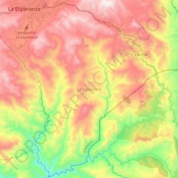
Naam: Topografische kaart La Esperanza, hoogte, reliëf.
Locatie: La Esperanza, Intibucá, Honduras (14.15984 -88.21838 14.31400 -88.05575)
Gemiddelde hoogte: 1.492 m
Minimale hoogte: 898 m
Maximale hoogte: 2.025 m
Andere topografische kaarten
Klik op een kaart om zijn topografie, zijn hoogte en zijn reliëf te bekijken.
Yamaranguila
Honduras > Intibucá > Yamaranguila
Yamaranguila, Intibucá, Honduras
Gemiddelde hoogte: 1.753 m
Cerro El Pelón
Honduras > Intibucá > La Esperanza
Cerro El Pelón, La Esperanza, Intibucá, Honduras
Gemiddelde hoogte: 1.913 m
La Esperanza
Honduras > Intibucá > La Esperanza
La Esperanza, Intibucá, Honduras
Gemiddelde hoogte: 1.534 m
Jesús de Otoro
Honduras > Intibucá > Jesús de Otoro
Jesús de Otoro, Intibucá, Honduras
Gemiddelde hoogte: 741 m
Río Guarajambala
Honduras > Intibucá > La Esperanza
Río Guarajambala, La Esperanza, Intibucá, Honduras
Gemiddelde hoogte: 489 m