
Doe een donatie
Rust jezelf uit voor je volgende avontuur:
Als Amazon-partner verdient deze site een commissie op in aanmerking komende aankopen, zonder extra kosten voor jou.
Topografische kaart Le Bacchus
Klik op de kaart om de hoogte weer te geven.
Doe een donatie
Rust jezelf uit voor je volgende avontuur:
Als Amazon-partner verdient deze site een commissie op in aanmerking komende aankopen, zonder extra kosten voor jou.
Over deze kaart
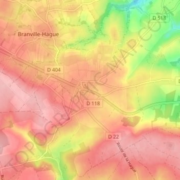
Naam: Topografische kaart Le Bacchus, hoogte, reliëf.
Gemiddelde hoogte: 140 m
Minimale hoogte: 55 m
Maximale hoogte: 183 m
Doe een donatie
Rust jezelf uit voor je volgende avontuur:
Als Amazon-partner verdient deze site een commissie op in aanmerking komende aankopen, zonder extra kosten voor jou.
Andere topografische kaarten
Klik op een kaart om zijn topografie, zijn hoogte en zijn reliëf te bekijken.
Sainte-Croix-Hague
France > Normandie > Manche > La Hague
Sainte-Croix-Hague est le point culminant du canton de Beaumont-Hague avec une altitude de 184 mètres au lieu-dit les Camps. Par cette position élevée, Sainte-Croix-Hague fut, dans l'histoire, le point de ralliement des envahisseurs. Le clocher de l'église, original en bulbe, ressemblant à celui de…
Gemiddelde hoogte: 143 m
Doe een donatie
Rust jezelf uit voor je volgende avontuur:
Als Amazon-partner verdient deze site een commissie op in aanmerking komende aankopen, zonder extra kosten voor jou.
Vasteville
France > Normandie > Manche > La Hague
Vasteville est située sur un plateau argileux à 106 mètres d'altitude entouré de collines et de plusieurs ruisseaux (de Bival, du Val Tolle et des Noes), à proximité du parc naturel régional des marais du Cotentin et du Bessin.
Gemiddelde hoogte: 114 m
Doe een donatie
Rust jezelf uit voor je volgende avontuur:
Als Amazon-partner verdient deze site een commissie op in aanmerking komende aankopen, zonder extra kosten voor jou.
Jobourg
France > Normandie > Manche > La Hague
Au cinéma, Jobourg apparaît comme décor dans Une vie d'Alexandre Astruc, et est cité comme lieu de l'un des deux meurtres du film Garde à vue de Claude Miller avec Michel Serrault, Lino Ventura et Romy Schneider. Plusieurs plans et de nombreuses indications topographiques de la ville y sont donnés.
Gemiddelde hoogte: 105 m
Doe een donatie
Rust jezelf uit voor je volgende avontuur:
Als Amazon-partner verdient deze site een commissie op in aanmerking komende aankopen, zonder extra kosten voor jou.
Doe een donatie
Rust jezelf uit voor je volgende avontuur:
Als Amazon-partner verdient deze site een commissie op in aanmerking komende aankopen, zonder extra kosten voor jou.
Vasteville
France > Normandie > Manche > La Hague
Vasteville est située sur un plateau argileux à 106 mètres d'altitude entouré de collines et de plusieurs ruisseaux (de Bival, du Val Tolle et des Noes), à proximité du parc naturel régional des Marais du Cotentin et du Bessin.
Gemiddelde hoogte: 114 m