
Topografische kaart Mo’orea
Interactieve kaart
Klik op de kaart om de hoogte weer te geven.
Mo’orea
Many Moʻorean endemic species that have gone extinct or been extirpated. The Polynesian tree snails of the genus Partula were largely wiped out after the rosy wolf snail was introduced in 1977, although captive and small refuge populations on Tahiti still exist. In 2019 the Partula rosea and Partula varia were reintroduced to the island. Until the 1980s, the Moʻorea reed warbler, an endemic species, was recorded on the island. This songbird was closely related to the Tahiti reed warbler and may have been displaced by the common myna. Another bird species extinct on Moʻorea is the Moʻorea sandpiper, of which only two specimens are known from 1777. The tree Glochidion nadeaudii is endemic to the island, growing in montane rain forests above 400 meters elevation.
Over deze kaart
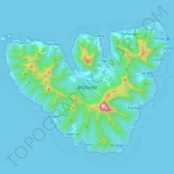
Naam: Topografische kaart Mo’orea, hoogte, reliëf.
Gemiddelde hoogte: 86 m
Minimale hoogte: 0 m
Maximale hoogte: 1.202 m
Andere topografische kaarten
Klik op een kaart om zijn topografie, zijn hoogte en zijn reliëf te bekijken.