
Topografische kaart Kluane National Park and Reserve
Interactieve kaart
Klik op de kaart om de hoogte weer te geven.
Over deze kaart
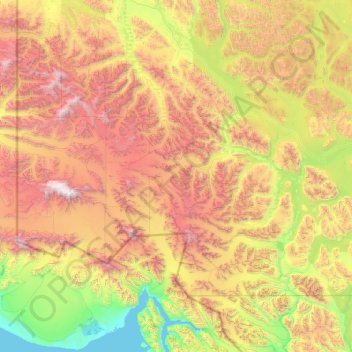
Naam: Topografische kaart Kluane National Park and Reserve, hoogte, reliëf.
Locatie: Kluane National Park and Reserve, Yukon, Canada (59.99484 -141.00198 61.33741 -137.01009)
Gemiddelde hoogte: 1.536 m
Minimale hoogte: -1 m
Maximale hoogte: 5.841 m
The Reserve includes the highest mountain in Canada, Mount Logan (5,959 metres or 19,551 feet) of the Saint Elias Mountains. Mountains and glaciers dominate the park's landscape, covering 83% of its area. The rest of the land in the park is forest and tundra—east of the largest mountains and glaciers—where the climate is colder and drier than in the western and southern parts of the park. Trees grow only at the park's lowest elevations. The primary tree species are white spruce, balsam poplar and trembling aspen.
Andere topografische kaarten
Klik op een kaart om zijn topografie, zijn hoogte en zijn reliëf te bekijken.
Two Mile Village
Canada > Yukon > Watson Lake
Two Mile Village, Watson Lake, Yukon, Y0A 1C0, Canada
Gemiddelde hoogte: 703 m
Destruction Bay
Canada > Yukon > Destruction Bay
Destruction Bay, Yukon, Y0B 1H0, Canada
Gemiddelde hoogte: 893 m
Dawson City
Canada > Yukon > Dawson City > Dawson City
Dawson City, Yukon, Y0B 1G0, Canada
Gemiddelde hoogte: 510 m
Yukon, Unorganized
City of Whitehorse, Yukon, Unorganized, Yukon, Canada
Gemiddelde hoogte: 1.010 m
Swift River
Canada > Yukon > Swift River
Swift River, Yukon, Unorganized, Yukon, Canada
Gemiddelde hoogte: 1.086 m