
Doe een donatie
Rust jezelf uit voor je volgende avontuur:
Als Amazon-partner verdient deze site een commissie op in aanmerking komende aankopen, zonder extra kosten voor jou.
Topografische kaart Bridgewater
Klik op de kaart om de hoogte weer te geven.
Doe een donatie
Rust jezelf uit voor je volgende avontuur:
Als Amazon-partner verdient deze site een commissie op in aanmerking komende aankopen, zonder extra kosten voor jou.
Bridgewater
Bridgewater spans the width of the LaHave River Valley and is dominated by hills that lead down to the river. Elevations range from 5 metres above sea level at the river, to nearly 110 m at the southwestern border. Like much of Southern Nova Scotia, the surrounding area is characterized by rolling drumlins formed during the last glacial period, some of which reach 150 metres above sea level. The LaHave River is traversed by two bridges in the centre of the town, as well as a 103 highway overpass and foot bridge towards the northern limits.
Doe een donatie
Rust jezelf uit voor je volgende avontuur:
Als Amazon-partner verdient deze site een commissie op in aanmerking komende aankopen, zonder extra kosten voor jou.
Over deze kaart
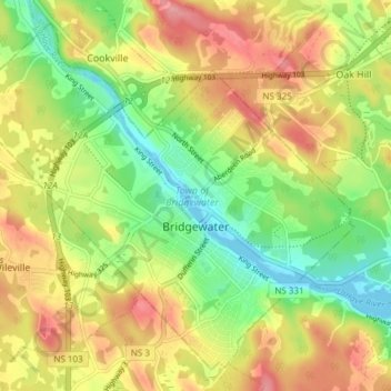
Naam: Topografische kaart Bridgewater, hoogte, reliëf.
Locatie: Bridgewater, Lunenburg County, Nova Scotia, Canada (44.35760 -64.56427 44.40550 -64.48875)
Gemiddelde hoogte: 56 m
Minimale hoogte: -2 m
Maximale hoogte: 118 m
Doe een donatie
Rust jezelf uit voor je volgende avontuur:
Als Amazon-partner verdient deze site een commissie op in aanmerking komende aankopen, zonder extra kosten voor jou.
Andere topografische kaarten
Klik op een kaart om zijn topografie, zijn hoogte en zijn reliëf te bekijken.
Doe een donatie
Rust jezelf uit voor je volgende avontuur:
Als Amazon-partner verdient deze site een commissie op in aanmerking komende aankopen, zonder extra kosten voor jou.