
Topografische kaart Faraya
Interactieve kaart
Klik op de kaart om de hoogte weer te geven.
Over deze kaart
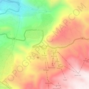
Naam: Topografische kaart Faraya, hoogte, reliëf.
Locatie: Faraya, Keserwan District, Mount Lebanon Governorate, Lebanon (33.97511 35.81728 34.01511 35.85728)
Gemiddelde hoogte: 1.846 m
Minimale hoogte: 1.260 m
Maximale hoogte: 2.326 m
Faraya (Arabic: فاريا) is a village and municipality in the Keserwan District of the Mount Lebanon Governorate, Lebanon. It is located 46 kilometers north of Beirut. Its average elevation is 1290 meters above sea level and its total land area is 870 hectares. Faraya's inhabitants are predominantly Maronite Christians.