
Doe een donatie
Rust jezelf uit voor je volgende avontuur:
Als Amazon-partner verdient deze site een commissie op in aanmerking komende aankopen, zonder extra kosten voor jou.
Topografische kaart Catanzaro
Klik op de kaart om de hoogte weer te geven.
Doe een donatie
Rust jezelf uit voor je volgende avontuur:
Als Amazon-partner verdient deze site een commissie op in aanmerking komende aankopen, zonder extra kosten voor jou.
Catanzaro
Catanzaro overlooks the Gulf of Squillace, in the Ionian Sea. The district of Catanzaro stretches from the sea to an elevation of 600 metres (2,000 ft). The historic center is approximately 300 metres (980 ft) above sea level. The town dates back to the valley of Fiumarella (formerly known as River Zaro). The Bishopric, St. Tryphon (or San Rocco) and St. John (or castle) marks the city's historical centre and is connected to the North Sila. Due to its particular geography, the municipality gets wet from the sea and is still subjected to a snowy winter. Catanzaro's rivers include the mainstream of the Fiumarella (in local dialect Hjiumareddha), which joins with the river Musofalo, and the torrent Corach (formerly called Crotalo).
Doe een donatie
Rust jezelf uit voor je volgende avontuur:
Als Amazon-partner verdient deze site een commissie op in aanmerking komende aankopen, zonder extra kosten voor jou.
Over deze kaart
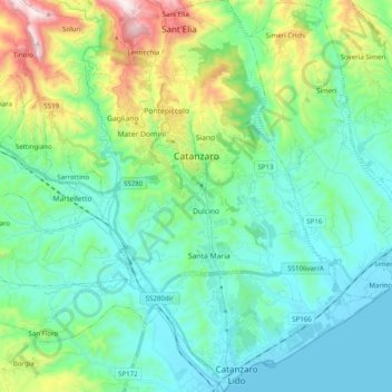
Naam: Topografische kaart Catanzaro, hoogte, reliëf.
Locatie: Catanzaro, Calabria, Italy (38.81484 16.53903 38.96858 16.68686)
Gemiddelde hoogte: 195 m
Minimale hoogte: 0 m
Maximale hoogte: 847 m
Doe een donatie
Rust jezelf uit voor je volgende avontuur:
Als Amazon-partner verdient deze site een commissie op in aanmerking komende aankopen, zonder extra kosten voor jou.