
Doe een donatie
Rust jezelf uit voor je volgende avontuur:
Als Amazon-partner verdient deze site een commissie op in aanmerking komende aankopen, zonder extra kosten voor jou.
Topografische kaart Rocky Mountains
Klik op de kaart om de hoogte weer te geven.
Doe een donatie
Rust jezelf uit voor je volgende avontuur:
Als Amazon-partner verdient deze site een commissie op in aanmerking komende aankopen, zonder extra kosten voor jou.
Over deze kaart
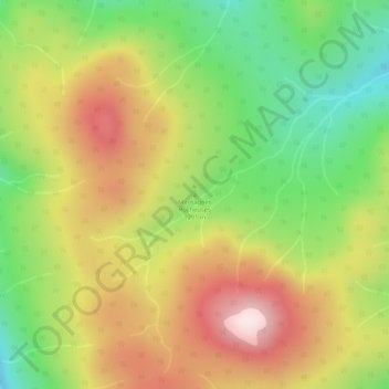
Naam: Topografische kaart Rocky Mountains, hoogte, reliëf.
Gemiddelde hoogte: 1.329 m
Minimale hoogte: 1.122 m
Maximale hoogte: 1.554 m
Doe een donatie
Rust jezelf uit voor je volgende avontuur:
Als Amazon-partner verdient deze site een commissie op in aanmerking komende aankopen, zonder extra kosten voor jou.
Andere topografische kaarten
Klik op een kaart om zijn topografie, zijn hoogte en zijn reliëf te bekijken.
Tetsa River
Canada > British Columbia > Northern Rockies Regional Municipality
Gemiddelde hoogte: 1.610 m
Muncho Lake
Canada > British Columbia > Northern Rockies Regional Municipality
The lake is part of the Muncho Lake Provincial Park and located at kilometre 681 (mile 423) of the Alaska Highway. The lake is about 12 km (7.5 mi) long and its width varies. It reaches a maximum depth of 110 m (360 ft). The surrounding peaks (the Terminal Range of the Muskwa Ranges to the west and the…
Gemiddelde hoogte: 1.322 m