
Topografische kaart Micanopy
Interactieve kaart
Klik op de kaart om de hoogte weer te geven.
Over deze kaart
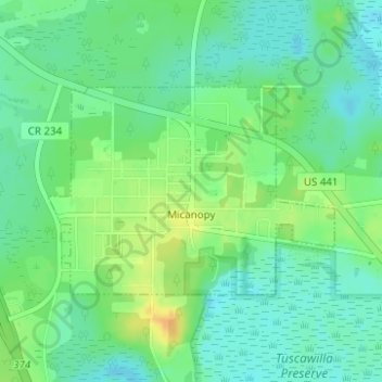
Naam: Topografische kaart Micanopy, hoogte, reliëf.
Locatie: Micanopy, Alachua County, Florida, United States (29.49882 -82.29127 29.51355 -82.26792)
Gemiddelde hoogte: 30 m
Minimale hoogte: 18 m
Maximale hoogte: 48 m
Andere topografische kaarten
Klik op een kaart om zijn topografie, zijn hoogte en zijn reliëf te bekijken.
Archer
United States > Florida > Alachua County
Archer, Alachua County, Florida, 32618, United States
Gemiddelde hoogte: 25 m
Gainesville
United States > Florida > Alachua County
Gainesville, Alachua County, Florida, United States
Gemiddelde hoogte: 42 m
Hawthorne
United States > Florida > Alachua County
Hawthorne, Alachua County, Florida, United States
Gemiddelde hoogte: 36 m
Newberry
United States > Florida > Alachua County
Newberry, Alachua County, Florida, United States
Gemiddelde hoogte: 27 m
Archer
United States > Florida > Alachua County > Archer
Archer, Alachua County, Florida, 32618, United States
Gemiddelde hoogte: 25 m
Waldo
United States > Florida > Alachua County > Waldo
Waldo, Alachua County, Florida, United States
Gemiddelde hoogte: 46 m
Depot Park
United States > Florida > Alachua County > Gainesville
Depot Park, Gainesville, Alachua County, Florida, United States
Gemiddelde hoogte: 43 m
City of Gainesville Municipal Boundaries
United States > Florida > Alachua County > City of Gainesville Municipal Boundaries
City of Gainesville Municipal Boundaries, Alachua County, Florida, United States
Gemiddelde hoogte: 42 m
High Springs
United States > Florida > Alachua County
High Springs, Alachua County, Florida, 32655, United States
Gemiddelde hoogte: 25 m