
Topografische kaart Jackson Hole
Interactieve kaart
Klik op de kaart om de hoogte weer te geven.
Over deze kaart
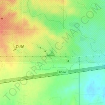
Naam: Topografische kaart Jackson Hole, hoogte, reliëf.
Locatie: Jackson Hole, Comanche County, Oklahoma, United States (34.64027 -98.67810 34.64194 -98.67566)
Gemiddelde hoogte: 406 m
Minimale hoogte: 384 m
Maximale hoogte: 427 m
Andere topografische kaarten
Klik op een kaart om zijn topografie, zijn hoogte en zijn reliëf te bekijken.
Meers
United States > Oklahoma > Comanche County
Meers, Comanche County, Oklahoma, United States
Gemiddelde hoogte: 457 m
Lake Lawtonka
United States > Oklahoma > Comanche County
Lake Lawtonka, Comanche County, Oklahoma, United States
Gemiddelde hoogte: 428 m
Lawton
United States > Oklahoma > Comanche County
Lawton, Comanche County, Oklahoma, United States
Gemiddelde hoogte: 352 m
Indiahoma
United States > Oklahoma > Comanche County
Indiahoma, Comanche County, Oklahoma, United States
Gemiddelde hoogte: 405 m
Geronimo
United States > Oklahoma > Comanche County
Geronimo, Comanche County, Oklahoma, 73543, United States
Gemiddelde hoogte: 328 m
Chattanooga
United States > Oklahoma > Comanche County
Chattanooga, Comanche County, Oklahoma, 73528, United States
Gemiddelde hoogte: 347 m
Faxon
United States > Oklahoma > Comanche County
Faxon, Comanche County, Oklahoma, United States
Gemiddelde hoogte: 334 m
Sterling
United States > Oklahoma > Comanche County
Sterling, Comanche County, Oklahoma, 73567, United States
Gemiddelde hoogte: 372 m
Fletcher
United States > Oklahoma > Comanche County
Fletcher, Comanche County, Oklahoma, United States
Gemiddelde hoogte: 417 m
Cache
United States > Oklahoma > Comanche County
Cache, Comanche County, Oklahoma, 73527, United States
Gemiddelde hoogte: 386 m
Fort Sill
United States > Oklahoma > Comanche County
Fort Sill, Comanche County, Oklahoma, United States
Gemiddelde hoogte: 417 m
Elk Mountain
United States > Oklahoma > Comanche County
Elk Mountain, Comanche County, Oklahoma, United States
Gemiddelde hoogte: 543 m
Elgin
United States > Oklahoma > Comanche County
Elgin, Comanche County, Oklahoma, United States
Gemiddelde hoogte: 393 m
Pratt Hill
United States > Oklahoma > Comanche County
Pratt Hill, Comanche County, Oklahoma, 73557, United States
Gemiddelde hoogte: 442 m
Lawton
United States > Oklahoma > Comanche County > Lawton
Lawton, Comanche County, Oklahoma, 73501, United States
Gemiddelde hoogte: 361 m
Mount McKinley
United States > Oklahoma > Comanche County
Mount McKinley, Comanche County, Oklahoma, United States
Gemiddelde hoogte: 498 m
Cove Acres
United States > Oklahoma > Comanche County > Cove Acres
Cove Acres, Comanche County, Oklahoma, 73006, United States
Gemiddelde hoogte: 381 m
Cross Mountain
United States > Oklahoma > Comanche County
Cross Mountain, Comanche County, Oklahoma, United States
Gemiddelde hoogte: 530 m
Medicine Park
United States > Oklahoma > Comanche County
Medicine Park, Comanche County, Oklahoma, 73557, United States
Gemiddelde hoogte: 429 m