
Topografische kaart Abbey St. Bathans
Interactieve kaart
Klik op de kaart om de hoogte weer te geven.
Over deze kaart
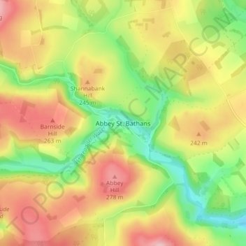
Naam: Topografische kaart Abbey St. Bathans, hoogte, reliëf.
Gemiddelde hoogte: 212 m
Minimale hoogte: 128 m
Maximale hoogte: 296 m
Abbey St Bathans (Scottish Gaelic: Abaid Bhaoithin) is a parish in the Lammermuir district of Berwickshire, in the eastern part of the Scottish Borders. Unique in its topography, it is situated in a long winding steep wooded valley that follows the Whiteadder Water. The parish had a population of 106 at the 2011 Census.
Andere topografische kaarten
Klik op een kaart om zijn topografie, zijn hoogte en zijn reliëf te bekijken.
Stow
United Kingdom > Scotland > Scottish Borders
Stow, Scottish Borders, Scotland, TD1 2RE, United Kingdom
Gemiddelde hoogte: 268 m
Blacklaw
United Kingdom > Scotland > Scottish Borders
Blacklaw, Scottish Borders, Scotland, ML12 6QR, United Kingdom
Gemiddelde hoogte: 360 m
West Linton
United Kingdom > Scotland > Scottish Borders
West Linton, Scottish Borders, Scotland, EH46 7ED, United Kingdom
Gemiddelde hoogte: 264 m
Cappercleuch
United Kingdom > Scotland > Scottish Borders
Cappercleuch, Scottish Borders, Scotland, TD7 5LG, United Kingdom
Gemiddelde hoogte: 378 m
Roberton
United Kingdom > Scotland > Scottish Borders > Roberton
Roberton, Scottish Borders, Scotland, TD9 7LX, United Kingdom
Gemiddelde hoogte: 244 m
Kelso
United Kingdom > Scotland > Scottish Borders
Kelso, Scottish Borders, Scotland, TD5 7HG, United Kingdom
Gemiddelde hoogte: 79 m