
Topografische kaart Glasgow
Interactieve kaart
Klik op de kaart om de hoogte weer te geven.
Over deze kaart
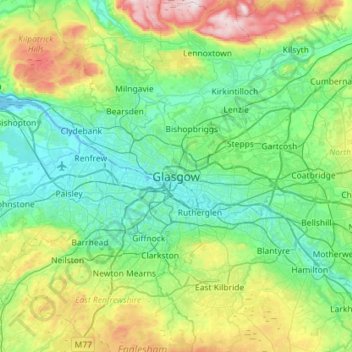
Naam: Topografische kaart Glasgow, hoogte, reliëf.
Locatie: Glasgow, Glasgow City, Scotland, G2 1DY, United Kingdom (55.70116 -4.41017 56.02116 -4.09017)
Gemiddelde hoogte: 128 m
Minimale hoogte: -5 m
Maximale hoogte: 554 m
Glasgow itself was reputed to have been founded by the Christian missionary Saint Mungo in the 6th century. He established a church on the Molendinar Burn, where the present Glasgow Cathedral stands, and in the following years Glasgow became a religious centre. Glasgow grew over the following centuries. The Glasgow Fair reportedly began in 1190. The first bridge over the River Clyde at Glasgow was recorded from around 1285, giving its name to the Briggait area of the city, forming the main north–south route over the river via Glasgow Cross. The founding of the University of Glasgow in 1451 and elevation of the bishopric to become the Archdiocese of Glasgow in 1492 increased the town's religious and educational status and landed wealth. Its early trade was in agriculture, brewing and fishing, with cured salmon and herring being exported to Europe and the Mediterranean.
Andere topografische kaarten
Klik op een kaart om zijn topografie, zijn hoogte en zijn reliëf te bekijken.
Forth and Clyde Canal Glasgow Spur Towpath
United Kingdom > Scotland > Glasgow City > Glasgow
Forth and Clyde Canal Glasgow Spur Towpath, Craighall, Rockvilla, Glasgow, Glasgow City, Scotland, G4 9SL, United Kingdom
Gemiddelde hoogte: 43 m
Cairnhill Woods
United Kingdom > Scotland > Glasgow City > Glasgow
Cairnhill Woods, Netherton, Glasgow, Glasgow City, Scotland, United Kingdom
Gemiddelde hoogte: 39 m