
Topografische kaart Oakland
Interactieve kaart
Klik op de kaart om de hoogte weer te geven.
Over deze kaart
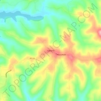
Naam: Topografische kaart Oakland, hoogte, reliëf.
Locatie: Oakland, Marion County, Arkansas, 72661, United States (36.44090 -92.59100 36.48090 -92.55100)
Gemiddelde hoogte: 259 m
Minimale hoogte: 196 m
Maximale hoogte: 343 m
Andere topografische kaarten
Klik op een kaart om zijn topografie, zijn hoogte en zijn reliëf te bekijken.
Yellville
United States > Arkansas > Marion County
Yellville, Marion County, Arkansas, 72687, United States
Gemiddelde hoogte: 211 m
Flippin
United States > Arkansas > Marion County
Flippin, Marion County, Arkansas, 72634, United States
Gemiddelde hoogte: 207 m
Peel
United States > Arkansas > Marion County
Peel, Marion County, Arkansas, 72668, United States
Gemiddelde hoogte: 244 m
Bull Shoals
United States > Arkansas > Marion County > Bull Shoals
Bull Shoals, Marion County, Arkansas, 72619, United States
Gemiddelde hoogte: 211 m
Pyatt
United States > Arkansas > Marion County > Pyatt
Pyatt, Marion County, Arkansas, 72672, United States
Gemiddelde hoogte: 260 m
Bull Shoals
United States > Arkansas > Marion County
Bull Shoals, Marion County, Arkansas, 72619, United States
Gemiddelde hoogte: 211 m