
Doe een donatie
Rust jezelf uit voor je volgende avontuur:
Als Amazon-partner verdient deze site een commissie op in aanmerking komende aankopen, zonder extra kosten voor jou.
Topografische kaart Area G (Salmo Valley)
Klik op de kaart om de hoogte weer te geven.
Doe een donatie
Rust jezelf uit voor je volgende avontuur:
Als Amazon-partner verdient deze site een commissie op in aanmerking komende aankopen, zonder extra kosten voor jou.
Over deze kaart
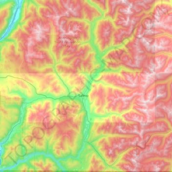
Naam: Topografische kaart Area G (Salmo Valley), hoogte, reliëf.
Gemiddelde hoogte: 1.395 m
Minimale hoogte: 447 m
Maximale hoogte: 2.362 m
Doe een donatie
Rust jezelf uit voor je volgende avontuur:
Als Amazon-partner verdient deze site een commissie op in aanmerking komende aankopen, zonder extra kosten voor jou.
Andere topografische kaarten
Klik op een kaart om zijn topografie, zijn hoogte en zijn reliëf te bekijken.
Ainsworth Hot Springs
Canada > British Columbia > Regional District of Central Kootenay > Area D (Lardeau Valley/Duncan Lake)
Gemiddelde hoogte: 741 m
Cooper Creek
Canada > British Columbia > Regional District of Central Kootenay > Area D (Lardeau Valley/Duncan Lake)
Gemiddelde hoogte: 1.573 m
Goat River
Canada > British Columbia > Regional District of Central Kootenay > Area B (Goat River Valley)
Gemiddelde hoogte: 1.713 m
Silent Pass
Canada > British Columbia > Regional District of Central Kootenay > Area D (Lardeau Valley/Duncan Lake)
Gemiddelde hoogte: 2.100 m
Doe een donatie
Rust jezelf uit voor je volgende avontuur:
Als Amazon-partner verdient deze site een commissie op in aanmerking komende aankopen, zonder extra kosten voor jou.
Keen Creek
Canada > British Columbia > Regional District of Central Kootenay > Area D (Lardeau Valley/Duncan Lake)
Gemiddelde hoogte: 976 m
Ymir
Canada > British Columbia > Regional District of Central Kootenay > Area G (Salmo Valley)
Gemiddelde hoogte: 967 m
Burton (Trout) Creek
Canada > British Columbia > Regional District of Central Kootenay > Area K (The Arrow Lakes)
Gemiddelde hoogte: 1.659 m
Passmore
Canada > British Columbia > Regional District of Central Kootenay > Area H (The Slocan Valley)
Gemiddelde hoogte: 819 m
Doe een donatie
Rust jezelf uit voor je volgende avontuur:
Als Amazon-partner verdient deze site een commissie op in aanmerking komende aankopen, zonder extra kosten voor jou.
Winlaw
Canada > British Columbia > Regional District of Central Kootenay > Area H (The Slocan Valley)
Gemiddelde hoogte: 694 m
Procter
Canada > British Columbia > Regional District of Central Kootenay > Area E (Balfour/Cottonwood Lake)
Gemiddelde hoogte: 715 m
Shoreacres
Canada > British Columbia > Regional District of Central Kootenay > Area I (Sentinel Mountain)
Gemiddelde hoogte: 632 m
Kingsgate
Canada > British Columbia > Regional District of Central Kootenay > Area B (Goat River Valley)
Gemiddelde hoogte: 979 m
Doe een donatie
Rust jezelf uit voor je volgende avontuur:
Als Amazon-partner verdient deze site een commissie op in aanmerking komende aankopen, zonder extra kosten voor jou.
Krestova
Canada > British Columbia > Regional District of Central Kootenay > Area H (The Slocan Valley)
Gemiddelde hoogte: 640 m
Rockslide Lake
Canada > British Columbia > Regional District of Central Kootenay > Area F (Kokanee Range)
Gemiddelde hoogte: 1.605 m
Gibson Creek
Canada > British Columbia > Regional District of Central Kootenay > Area I (Sentinel Mountain)
Gemiddelde hoogte: 778 m
Crawford Bay
Canada > British Columbia > Regional District of Central Kootenay > Area A (Wynndel/Crawford Bay/Riondel)
Gemiddelde hoogte: 667 m
Doe een donatie
Rust jezelf uit voor je volgende avontuur:
Als Amazon-partner verdient deze site een commissie op in aanmerking komende aankopen, zonder extra kosten voor jou.
Vallican
Canada > British Columbia > Regional District of Central Kootenay > Area H (The Slocan Valley)
Gemiddelde hoogte: 821 m
Blewett
Canada > British Columbia > Regional District of Central Kootenay > Area E (Balfour/Cottonwood Lake) > Blewett
Gemiddelde hoogte: 837 m
Castlegar
Canada > British Columbia > Regional District of Central Kootenay > Castlegar
Gemiddelde hoogte: 1.207 m
Kitchener
Canada > British Columbia > Regional District of Central Kootenay > Area B (Goat River Valley)
Gemiddelde hoogte: 925 m
Doe een donatie
Rust jezelf uit voor je volgende avontuur:
Als Amazon-partner verdient deze site een commissie op in aanmerking komende aankopen, zonder extra kosten voor jou.
Pass Creek
Canada > British Columbia > Regional District of Central Kootenay > Area I (Sentinel Mountain)
Gemiddelde hoogte: 751 m
Kootenay Canal
Canada > British Columbia > Regional District of Central Kootenay > Nelson
Gemiddelde hoogte: 663 m
Boswell
Canada > British Columbia > Regional District of Central Kootenay > Area A (Wynndel/Crawford Bay/Riondel)
Gemiddelde hoogte: 779 m
Stoney Creek
Canada > British Columbia > Regional District of Central Kootenay > Area K (The Arrow Lakes)
Gemiddelde hoogte: 1.295 m
Doe een donatie
Rust jezelf uit voor je volgende avontuur:
Als Amazon-partner verdient deze site een commissie op in aanmerking komende aankopen, zonder extra kosten voor jou.
Taghum
Canada > British Columbia > Regional District of Central Kootenay > Area F (Kokanee Range)
Gemiddelde hoogte: 745 m
Poplar Creek
Canada > British Columbia > Regional District of Central Kootenay > Area D (Lardeau Valley/Duncan Lake)
Gemiddelde hoogte: 1.732 m
Granite
Canada > British Columbia > Regional District of Central Kootenay > Area E (Balfour/Cottonwood Lake) > Blewett
Gemiddelde hoogte: 772 m
Mount Nemo
Canada > British Columbia > Regional District of Central Kootenay > Area D (Lardeau Valley/Duncan Lake)
Gemiddelde hoogte: 2.283 m
Doe een donatie
Rust jezelf uit voor je volgende avontuur:
Als Amazon-partner verdient deze site een commissie op in aanmerking komende aankopen, zonder extra kosten voor jou.
South Slocan
Canada > British Columbia > Regional District of Central Kootenay > Area H (The Slocan Valley)
Gemiddelde hoogte: 578 m
Nelway
Canada > British Columbia > Regional District of Central Kootenay > Area G (Salmo Valley)
Gemiddelde hoogte: 924 m
Sandon
Canada > British Columbia > Regional District of Central Kootenay > Area H (The Slocan Valley)
Gemiddelde hoogte: 1.529 m
Doe een donatie
Rust jezelf uit voor je volgende avontuur:
Als Amazon-partner verdient deze site een commissie op in aanmerking komende aankopen, zonder extra kosten voor jou.
Riondel
Canada > British Columbia > Regional District of Central Kootenay > Area A (Wynndel/Crawford Bay/Riondel)
Gemiddelde hoogte: 675 m
Harrop
Canada > British Columbia > Regional District of Central Kootenay > Area E (Balfour/Cottonwood Lake)
Gemiddelde hoogte: 675 m
Raspberry
Canada > British Columbia > Regional District of Central Kootenay > Area J (Lower Arrow/Columbia)
Gemiddelde hoogte: 651 m
Butters Lake
Canada > British Columbia > Regional District of Central Kootenay > Area D (Lardeau Valley/Duncan Lake)
Gemiddelde hoogte: 2.133 m
Doe een donatie
Rust jezelf uit voor je volgende avontuur:
Als Amazon-partner verdient deze site een commissie op in aanmerking komende aankopen, zonder extra kosten voor jou.
Crescent Valley
Canada > British Columbia > Regional District of Central Kootenay > Area H (The Slocan Valley)
Gemiddelde hoogte: 602 m
Mazinaw Mountain
Canada > British Columbia > Regional District of Central Kootenay > Area D (Lardeau Valley/Duncan Lake)
Gemiddelde hoogte: 2.578 m
Lemon Creek
Canada > British Columbia > Regional District of Central Kootenay > Area H (The Slocan Valley)
Gemiddelde hoogte: 1.527 m
Playmor Junction
Canada > British Columbia > Regional District of Central Kootenay > Area H (The Slocan Valley) > South Slocan
Gemiddelde hoogte: 578 m
Doe een donatie
Rust jezelf uit voor je volgende avontuur:
Als Amazon-partner verdient deze site een commissie op in aanmerking komende aankopen, zonder extra kosten voor jou.
Goatfell
Canada > British Columbia > Regional District of Central Kootenay > Area B
Gemiddelde hoogte: 975 m
Kokanee Creek
Canada > British Columbia > Regional District of Central Kootenay > Area E (Balfour/Cottonwood Lake)
Gemiddelde hoogte: 2.022 m
Burton
Canada > British Columbia > Regional District of Central Kootenay > Area K (The Arrow Lakes)
Gemiddelde hoogte: 578 m
Bentz Peak
Canada > British Columbia > Regional District of Central Kootenay > Area J (Lower Arrow/Columbia)
Gemiddelde hoogte: 2.037 m
Doe een donatie
Rust jezelf uit voor je volgende avontuur:
Als Amazon-partner verdient deze site een commissie op in aanmerking komende aankopen, zonder extra kosten voor jou.
Columbia River
Canada > British Columbia > Regional District of Central Kootenay > Castlegar
Gemiddelde hoogte: 598 m
Balfour
Canada > British Columbia > Regional District of Central Kootenay > Area E (Balfour/Cottonwood Lake)
Gemiddelde hoogte: 673 m
Erickson
Canada > British Columbia > Regional District of Central Kootenay > Area B (Goat River Valley)
Gemiddelde hoogte: 680 m
Commonwealth Mountain
Canada > British Columbia > Regional District of Central Kootenay > Area G (Salmo Valley)
Gemiddelde hoogte: 1.871 m
Doe een donatie
Rust jezelf uit voor je volgende avontuur:
Als Amazon-partner verdient deze site een commissie op in aanmerking komende aankopen, zonder extra kosten voor jou.
Hall Creek
Canada > British Columbia > Regional District of Central Kootenay > Area G (Salmo Valley)
Gemiddelde hoogte: 1.570 m
Procter
Canada > British Columbia > Regional District of Central Kootenay > Area E (Balfour/Cottonwood Lake)
Gemiddelde hoogte: 715 m