
Doe een donatie
Rust jezelf uit voor je volgende avontuur:
Als Amazon-partner verdient deze site een commissie op in aanmerking komende aankopen, zonder extra kosten voor jou.
Topografische kaart Sable Island
Klik op de kaart om de hoogte weer te geven.
Doe een donatie
Rust jezelf uit voor je volgende avontuur:
Als Amazon-partner verdient deze site een commissie op in aanmerking komende aankopen, zonder extra kosten voor jou.
Sable Island
Sable Island is a narrow, crescent-shaped sandbar with a surface area estimated around 34 km2 (13 sq mi). Despite being approximately 43.15 km (26.81 mi) long, it is only 1.21 km (0.75 mi) across at its widest point. The maximum elevation is about 30 m (98 ft). The long crescent-shaped island rises gently from the shallows of the continental shelf approximately 285 km (177 mi) east of Halifax, Nova Scotia. Its location, in tandem with the area's frequent fog and sudden strong storms e.g. hurricanes and nor'easters, have resulted in over 350 recorded shipwrecks. It is often referred to as the Graveyard of the Atlantic, as it sits astride the great circle route from North America's east coast to Europe. The nearest landfall is 160 kilometres (99 mi) to the northwest near Canso, Nova Scotia.
Doe een donatie
Rust jezelf uit voor je volgende avontuur:
Als Amazon-partner verdient deze site een commissie op in aanmerking komende aankopen, zonder extra kosten voor jou.
Over deze kaart
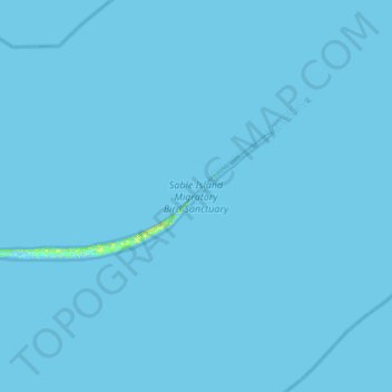
Naam: Topografische kaart Sable Island, hoogte, reliëf.
Gemiddelde hoogte: 0 m
Minimale hoogte: -5 m
Maximale hoogte: 19 m
Doe een donatie
Rust jezelf uit voor je volgende avontuur:
Als Amazon-partner verdient deze site een commissie op in aanmerking komende aankopen, zonder extra kosten voor jou.