
Topografische kaart Ashover Hay
Klik op de kaart om de hoogte weer te geven.
Over deze kaart
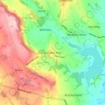
Naam: Topografische kaart Ashover Hay, hoogte, reliëf.
Gemiddelde hoogte: 198 m
Minimale hoogte: 104 m
Maximale hoogte: 319 m
Andere topografische kaarten
Klik op een kaart om zijn topografie, zijn hoogte en zijn reliëf te bekijken.
North Wingfield
United Kingdom > England > Derbyshire > North East Derbyshire
Gemiddelde hoogte: 126 m
Ogston Reservoir
United Kingdom > England > Derbyshire > North East Derbyshire > Woolley Moor
Gemiddelde hoogte: 137 m
Doghole Wood
United Kingdom > England > Derbyshire > North East Derbyshire > Holymoorside
Gemiddelde hoogte: 142 m
Brackenfield CP
United Kingdom > England > Derbyshire > North East Derbyshire
Gemiddelde hoogte: 168 m
Dronfield Nature Park
United Kingdom > England > Derbyshire > North East Derbyshire > Dronfield > Unstone Green
Gemiddelde hoogte: 156 m
Ashover CP
United Kingdom > England > Derbyshire > North East Derbyshire
By the 18th century, there were several thousand acres of unenclosed moorland in the parish of Ashover, principally covered with heath. The only paths across this wilderness for roads were tracks in the sand or heath with here and there a stone post on the hills or elevations to serve as guides to the…
Gemiddelde hoogte: 210 m
Norwood Cottage Lakes
United Kingdom > England > Derbyshire > North East Derbyshire > Killamarsh
Gemiddelde hoogte: 93 m
Grassmoor Country Park
United Kingdom > England > Derbyshire > North East Derbyshire > Corbriggs
Gemiddelde hoogte: 116 m
Holmesfield
United Kingdom > England > Derbyshire > North East Derbyshire > Holmesfield
Gemiddelde hoogte: 233 m