
Topografische kaart Kosjerić (town)
Interactieve kaart
Klik op de kaart om de hoogte weer te geven.
Over deze kaart
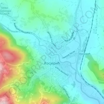
Naam: Topografische kaart Kosjerić (town), hoogte, reliëf.
Gemiddelde hoogte: 465 m
Minimale hoogte: 398 m
Maximale hoogte: 695 m
Kosjeríć (Serbian Cyrillic: Косјерић, pronounced [kɔsjɛ̌rit͡ɕ]) is a town and municipality located in the Zlatibor District of western Serbia. The municipality has a population of 12,090 inhabitants, but the town itself has 3,992. The municipality's area is 359 square kilometres (139 sq mi), with 26 villages mostly placed in the river valleys, though there are also some settlements in the mountains at altitudes of more than 1,000 metres (3,300 feet).
Andere topografische kaarten
Klik op een kaart om zijn topografie, zijn hoogte en zijn reliëf te bekijken.
Radanovci
Serbia > Central Serbia > Zlatibor Administrative District > Kosjeric Municipality
Radanovci, Kosjeric Municipality, Zlatibor Administrative District, Central Serbia, Serbia
Gemiddelde hoogte: 691 m