Topografische kaart Le Pied du Col
Interactieve kaart
Klik op de kaart om de hoogte weer te geven.
Over deze kaart
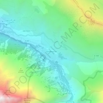
Naam: Topografische kaart Le Pied du Col, hoogte, reliëf.
Gemiddelde hoogte: 2.101 m
Minimale hoogte: 1.592 m
Maximale hoogte: 3.433 m

Klik op de kaart om de hoogte weer te geven.
Naam: Topografische kaart Le Pied du Col, hoogte, reliëf.
Gemiddelde hoogte: 2.101 m
Minimale hoogte: 1.592 m
Maximale hoogte: 3.433 m