Geolokaliseren

Topografische kaart Nuneaton

Interactieve kaart

Klik op de kaart om de hoogte weer te geven.

Over deze kaart

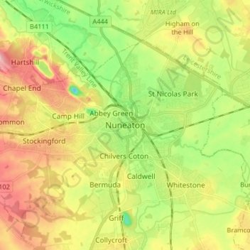
Naam: Topografische kaart Nuneaton, hoogte, reliëf.

Locatie: Nuneaton, Nuneaton and Bedworth, Warwickshire, England, CV11 5AB, United Kingdom (52.48462 -1.50845 52.56462 -1.42845)

Gemiddelde hoogte: 101 m

Minimale hoogte: 39 m

Maximale hoogte: 172 m

Andere topografische kaarten

Klik op een kaart om zijn topografie, zijn hoogte en zijn reliëf te bekijken.

Nuneaton Common

United Kingdom > England > Warwickshire > Nuneaton and Bedworth

Nuneaton Common, Whittleford, Nuneaton and Bedworth, Warwickshire, England, United Kingdom

Gemiddelde hoogte: 127 m

Ash Green

United Kingdom > England > Warwickshire > Nuneaton and Bedworth > Ash Green

Ash Green, Nuneaton and Bedworth, Warwickshire, England, CV7 9AQ, United Kingdom

Gemiddelde hoogte: 111 m

Horeston Grange

United Kingdom > England > Warwickshire > Nuneaton and Bedworth

Horeston Grange, Nuneaton and Bedworth, Warwickshire, England, CV11 6YL, United Kingdom

Gemiddelde hoogte: 90 m

Exhall

United Kingdom > England > Warwickshire > Nuneaton and Bedworth

Exhall, Nuneaton and Bedworth, Warwickshire, England, CV7 9DJ, United Kingdom

Gemiddelde hoogte: 101 m

Bedworth

United Kingdom > England > Warwickshire > Nuneaton and Bedworth

Bedworth, Nuneaton and Bedworth, Warwickshire, England, CV12 9DQ, United Kingdom

Gemiddelde hoogte: 105 m

Bulkington

United Kingdom > England > Warwickshire > Nuneaton and Bedworth

Bulkington, Nuneaton and Bedworth, Warwickshire, England, CV12 9NN, United Kingdom

Gemiddelde hoogte: 107 m