
Topografische kaart Anslow
Klik op de kaart om de hoogte weer te geven.
Over deze kaart
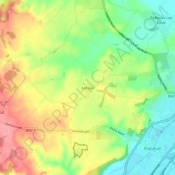
Naam: Topografische kaart Anslow, hoogte, reliëf.
Gemiddelde hoogte: 88 m
Minimale hoogte: 44 m
Maximale hoogte: 145 m
Andere topografische kaarten
Klik op een kaart om zijn topografie, zijn hoogte en zijn reliëf te bekijken.
Tutbury Castle
United Kingdom > England > Staffordshire > East Staffordshire > Tutbury
Gemiddelde hoogte: 66 m
Burton upon Trent
United Kingdom > England > Staffordshire > East Staffordshire
Burton is about 109 miles (175 km) north west of London, about 30 miles north east of Birmingham, the UK's second largest city and about 23 miles east of the county town Stafford. It is at the easternmost border of the county of Staffordshire with Derbyshire, its suburbs and the course of the River Trent…
Gemiddelde hoogte: 69 m
Stubwood
United Kingdom > England > Staffordshire > East Staffordshire > Denstone
Gemiddelde hoogte: 113 m
Birch Cross
United Kingdom > England > Staffordshire > East Staffordshire > Marchington
Gemiddelde hoogte: 92 m
Blithfield Reservoir
United Kingdom > England > Staffordshire > East Staffordshire > Admaston
Gemiddelde hoogte: 108 m
Gratwich
United Kingdom > England > Staffordshire > East Staffordshire > Kingstone
Gemiddelde hoogte: 143 m
Marchington Woodlands
United Kingdom > England > Staffordshire > East Staffordshire
Gemiddelde hoogte: 120 m
Harlow Wood
United Kingdom > England > Staffordshire > East Staffordshire > Upper Mayfield
Gemiddelde hoogte: 177 m
Burton upon Trent
United Kingdom > England > Staffordshire > East Staffordshire
Burton is about 109 miles (175 km) north west of London, about 30 miles north east of Birmingham, the UK's second largest city and about 23 miles east of the county town Stafford. It is at the easternmost border of the county of Staffordshire with Derbyshire, its suburbs and the course of the River Trent…
Gemiddelde hoogte: 69 m