
Topografische kaart Primorsky Krai
Interactieve kaart
Klik op de kaart om de hoogte weer te geven.
Primorsky Krai
Highlands dominate the territory of the krai. Most of the territory is mountainous, and almost 80% of it is forested. The average elevation is about 500 meters (1,600 ft). Sikhote-Alin is a mountainous formation, extending for the most part of the Krai. It consists of a number of parallel ranges: the Partizansky (Partisan), the Siny (Blue), the Kholodny (Cold), and others. There are many karst caves in the South of Primorye. The relatively accessible Spyashchaya Krasavitsa cave (the Sleeping Beauty) in the Ussuriysky Nature Preserve could be recommended for tourists. There are comparatively well-preserved fragments of the ancient volcanoes in the area.
Over deze kaart
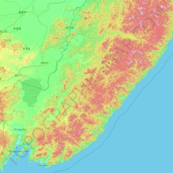
Naam: Topografische kaart Primorsky Krai, hoogte, reliëf.
Locatie: Primorsky Krai, Far Eastern Federal District, Russia (42.52195 132.16665 47.64195 137.28665)
Gemiddelde hoogte: 255 m
Minimale hoogte: -2 m
Maximale hoogte: 1.870 m
Andere topografische kaarten
Klik op een kaart om zijn topografie, zijn hoogte en zijn reliëf te bekijken.