Topografische kaart Schotland
Interactieve kaart
Klik op de kaart om de hoogte weer te geven.
Over deze kaart
![Topografische kaart Schotland, hoogte, reliëf](/pub/maps/relation/zk57/pdkdn/thumbnail.jpg)
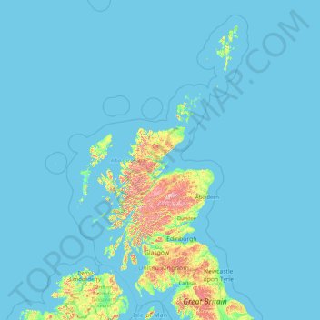
Naam: Topografische kaart Schotland, hoogte, reliëf.
Locatie: Schotland, Verenigd Koninkrijk (54.43398 -14.01552 61.06100 -0.32092)
Gemiddelde hoogte: 36 m
Minimale hoogte: 0 m
Maximale hoogte: 1.259 m
De Hooglanden liggen ten noorden en westen van de Highland Boundary Fault, die loopt van Arran tot Stonehaven. Dit gedeelte van Schotland is voornamelijk opgebouwd uit oud gesteente uit het Cambrium en Precambrium, die naar boven werden gedrukt tijdens de Caledonische orogenese. Het wordt doorsneden door stollingsgesteente van een recentere periode, waarvan de overblijfselen de huidige gebergten als de Cairngorms en de Cuillins vormen. Een belangrijke uitzondering zijn de lagen van Old Red Sandstone bij de kust van de Moray Firth, die talloze fossielen herbergen. De Schotse Hooglanden zijn in het algemeen bergachtig en de grootste hoogtes van de Britse Eilanden zijn er te vinden.
Andere topografische kaarten
Klik op een kaart om zijn topografie, zijn hoogte en zijn reliëf te bekijken.
![Topografische kaart Cheltenham, hoogte, reliëf](/pub/maps/relation/7mkl/7jhs8/icon.jpg)
Cheltenham
Verenigd Koninkrijk > Engeland > Gloucestershire
Cheltenham, Gloucestershire, Engeland, Verenigd Koninkrijk
Gemiddelde hoogte: 109 m
![Topografische kaart Aberfeldy, hoogte, reliëf](/pub/maps/node/l5gp/fmswf3gp/icon.jpg)
Aberfeldy
Verenigd Koninkrijk > Schotland > Perth and Kinross
Aberfeldy, Perth and Kinross, Schotland, PH15 2DD, Verenigd Koninkrijk
Gemiddelde hoogte: 304 m
![Topografische kaart South Downs National Park, hoogte, reliëf](/pub/maps/relation/d514/p37mdn/icon.jpg)
South Downs National Park
Verenigd Koninkrijk > Engeland > West Sussex
South Downs National Park, West Sussex, Engeland, Verenigd Koninkrijk
Gemiddelde hoogte: 54 m
![Topografische kaart Betws-y-coed, hoogte, reliëf](/pub/maps/relation/9cb3/b6bb3/icon.jpg)
Betws-y-coed
Verenigd Koninkrijk > Wales > Conwy
Betws-y-coed, Conwy, Wales, Verenigd Koninkrijk
Gemiddelde hoogte: 186 m
![Topografische kaart Oxford, hoogte, reliëf](/pub/maps/relation/gs5k/l2s3q/icon.jpg)
Oxford
Verenigd Koninkrijk > Engeland > Oxfordshire
Oxford, Oxfordshire, Engeland, Verenigd Koninkrijk
Gemiddelde hoogte: 81 m
![Topografische kaart Ruthin, hoogte, reliëf](/pub/maps/node/5b5k/d1bgqkl/icon.jpg)
Ruthin
Verenigd Koninkrijk > Wales > Denbighshire
Ruthin, Denbighshire, Wales, LL15 1BU, Verenigd Koninkrijk
Gemiddelde hoogte: 162 m
![Topografische kaart Tenby, hoogte, reliëf](/pub/maps/relation/x757/qq4t3l/icon.jpg)
Tenby
Verenigd Koninkrijk > Wales > Pembrokeshire
Tenby, Pembrokeshire, Wales, Verenigd Koninkrijk
Gemiddelde hoogte: 15 m
![Topografische kaart Ditton, hoogte, reliëf](/pub/maps/relation/sqz4/rt723q/icon.jpg)
Ditton
Verenigd Koninkrijk > Engeland > Kent > Tonbridge and Malling > Ditton
Ditton, Tonbridge and Malling, Kent, Engeland, Verenigd Koninkrijk
Gemiddelde hoogte: 37 m
![Topografische kaart Ullapool, hoogte, reliëf](/pub/maps/node/dbkl/gg2lz18/icon.jpg)
Ullapool
Verenigd Koninkrijk > Schotland > Highland
Ullapool, Highland, Schotland, IV26 2XE, Verenigd Koninkrijk
Gemiddelde hoogte: 150 m
![Topografische kaart Fort William, hoogte, reliëf](/pub/maps/node/9jf3/wtfstj/icon.jpg)
Fort William
Verenigd Koninkrijk > Schotland > Highland
Fort William, Highland, Schotland, PH33 6AQ, Verenigd Koninkrijk
Gemiddelde hoogte: 122 m
![Topografische kaart Killin, hoogte, reliëf](/pub/maps/way/hmt/m7dnqzz4/icon.jpg)
Killin
Verenigd Koninkrijk > Schotland > Stirling
Killin, Stirling, Schotland, Verenigd Koninkrijk
Gemiddelde hoogte: 174 m
![Topografische kaart Amersham, hoogte, reliëf](/pub/maps/relation/4gmt/7k5kzs/icon.jpg)
Amersham
Verenigd Koninkrijk > Engeland > Buckinghamshire > Chesham Bois
Amersham, Amersham and Villages Community Board, Chesham Bois, Buckinghamshire, Engeland, Verenigd Koninkrijk
Gemiddelde hoogte: 133 m
![Topografische kaart Peterhead, hoogte, reliëf](/pub/maps/node/31rr/4jwbs3l/icon.jpg)
Peterhead
Verenigd Koninkrijk > Schotland > Aberdeenshire
Peterhead, Aberdeenshire, Schotland, AB42 1ZP, Verenigd Koninkrijk
Gemiddelde hoogte: 17 m
![Topografische kaart Lake District National Park, hoogte, reliëf](/pub/maps/relation/msrr/5hbkl/icon.jpg)
Lake District National Park
Verenigd Koninkrijk > Engeland
Lake District National Park, Engeland, Verenigd Koninkrijk
Gemiddelde hoogte: 206 m
![Topografische kaart London Borough of Tower Hamlets, hoogte, reliëf](/pub/maps/relation/9w57/phwdn/icon.jpg)
London Borough of Tower Hamlets
Verenigd Koninkrijk > Engeland > Londen
London Borough of Tower Hamlets, Londen, Groot-Londen, Engeland, Verenigd Koninkrijk
Gemiddelde hoogte: 9 m
![Topografische kaart Coleshill, hoogte, reliëf](/pub/maps/relation/qsnx/slg71h/icon.jpg)
Coleshill
Verenigd Koninkrijk > Engeland > Buckinghamshire
Coleshill, Amersham and Villages Community Board, Winchmore Hill, Buckinghamshire, Engeland, Verenigd Koninkrijk
Gemiddelde hoogte: 137 m
![Topografische kaart Moher, hoogte, reliëf](/pub/maps/way/5557/bph763l/icon.jpg)
Moher
Verenigd Koninkrijk > Noord-Ierland
Moher, Lea, Fermanagh and Omagh District, Noord-Ierland, BT92 4FJ, Verenigd Koninkrijk
Gemiddelde hoogte: 65 m
![Topografische kaart Chadlington, hoogte, reliëf](/pub/maps/relation/dntp/m112dn/icon.jpg)
Chadlington
Verenigd Koninkrijk > Engeland > Oxfordshire > West Oxfordshire > Charlbury
Chadlington, Charlbury, West Oxfordshire, Oxfordshire, Engeland, Verenigd Koninkrijk
Gemiddelde hoogte: 161 m
![Topografische kaart Loch Teth, hoogte, reliëf](/pub/maps/way/lgt/flgzcb3/icon.jpg)
Loch Teth
Verenigd Koninkrijk > Schotland > Highland
Loch Teth, Highland, Schotland, Verenigd Koninkrijk
Gemiddelde hoogte: 94 m
![Topografische kaart Glencoe, hoogte, reliëf](/pub/maps/node/fptp/l9gs44s/icon.jpg)
Glencoe
Verenigd Koninkrijk > Schotland > Highland
Glencoe, Highland, Schotland, PH49 4HS, Verenigd Koninkrijk
Gemiddelde hoogte: 114 m
![Topografische kaart Walburn Hall, hoogte, reliëf](/pub/maps/node/qr57/fxsqdf14/icon.jpg)
Walburn Hall
Verenigd Koninkrijk > Engeland > North Yorkshire
Walburn Hall, Walburn, North Yorkshire, Engeland, DL11 6AF, Verenigd Koninkrijk
Gemiddelde hoogte: 257 m
![Topografische kaart Plymouth, hoogte, reliëf](/pub/maps/relation/rs5k/knpf3/icon.jpg)
Plymouth
Verenigd Koninkrijk > Engeland
Plymouth, Engeland, Verenigd Koninkrijk
Gemiddelde hoogte: 46 m
![Topografische kaart Glen Coe, hoogte, reliëf](/pub/maps/way/89m2/1nrph7m2/icon.jpg)
Glen Coe
Verenigd Koninkrijk > Schotland > Highland > Glencoe
Glen Coe, Glencoe, Highland, Schotland, Verenigd Koninkrijk
Gemiddelde hoogte: 414 m
![Topografische kaart Glen Etive, hoogte, reliëf](/pub/maps/way/p5k/c2qvh8cz/icon.jpg)
Glen Etive
Verenigd Koninkrijk > Schotland > Highland
Glen Etive, Highland, Schotland, Verenigd Koninkrijk
Gemiddelde hoogte: 477 m
![Topografische kaart Loch Bealach nam Buthan, hoogte, reliëf](/pub/maps/way/76f3/f75gtz4/icon.jpg)
Loch Bealach nam Buthan
Verenigd Koninkrijk > Schotland > Highland
Loch Bealach nam Buthan, Highland, Schotland, Verenigd Koninkrijk
Gemiddelde hoogte: 586 m
![Topografische kaart Heanor, hoogte, reliëf](/pub/maps/node/5nx/sbjblb3/icon.jpg)
Heanor
Verenigd Koninkrijk > Engeland > Derbyshire > Amber Valley
Heanor, Amber Valley, Derbyshire, Engeland, DE75 7EZ, Verenigd Koninkrijk
Gemiddelde hoogte: 102 m
![Topografische kaart River Etive, hoogte, reliëf](/pub/maps/way/68s8/kbhjx57/icon.jpg)
River Etive
Verenigd Koninkrijk > Schotland > Highland
River Etive, Highland, Schotland, Verenigd Koninkrijk
Gemiddelde hoogte: 331 m
![Topografische kaart Kilsyth, hoogte, reliëf](/pub/maps/node/vqrr/9wdnqnh/icon.jpg)
Kilsyth
Verenigd Koninkrijk > Schotland > North Lanarkshire
Kilsyth, North Lanarkshire, Schotland, G65 0AQ, Verenigd Koninkrijk
Gemiddelde hoogte: 161 m
![Topografische kaart The Mount, hoogte, reliëf](/pub/maps/node/9l4s/6dxpmdn/icon.jpg)
The Mount
Verenigd Koninkrijk > Engeland > Medway > Wainscott
The Mount, Frindsbury Extra, Wainscott, Frindsbury, Medway, Engeland, ME3 8BL, Verenigd Koninkrijk
Gemiddelde hoogte: 31 m
![Topografische kaart Manchester, hoogte, reliëf](/pub/maps/relation/9mzs/73gf3/icon.jpg)
Manchester
Verenigd Koninkrijk > Engeland
Manchester, Greater Manchester, Engeland, Verenigd Koninkrijk
Gemiddelde hoogte: 66 m
![Topografische kaart Erraid, hoogte, reliëf](/pub/maps/relation/kb3/9b9pgp/icon.jpg)
Erraid
Verenigd Koninkrijk > Schotland > Argyll and Bute
Erraid, Argyll and Bute, Schotland, Verenigd Koninkrijk
Gemiddelde hoogte: 8 m
![Topografische kaart Belstead, hoogte, reliëf](/pub/maps/relation/tt3q/m6j714/icon.jpg)
Belstead
Verenigd Koninkrijk > Engeland > Suffolk > Babergh
Belstead, Washbrook, Babergh, Suffolk, Engeland, Verenigd Koninkrijk
Gemiddelde hoogte: 32 m
![Topografische kaart Matlock, hoogte, reliëf](/pub/maps/node/68zs/x61m9z4/icon.jpg)
Matlock
Verenigd Koninkrijk > Engeland > Derbyshire > Derbyshire Dales
Matlock, Derbyshire Dales, Derbyshire, Engeland, DE4 3AP, Verenigd Koninkrijk
Gemiddelde hoogte: 213 m
![Topografische kaart Sandford Hill, hoogte, reliëf](/pub/maps/node/lfs8/ls4l8k4s/icon.jpg)
Sandford Hill
Verenigd Koninkrijk > Engeland > Stoke-on-Trent > Longton
Sandford Hill, Longton, Stoke-on-Trent, Engeland, ST3 1AS, Verenigd Koninkrijk
Gemiddelde hoogte: 169 m
![Topografische kaart Belfast, hoogte, reliëf](/pub/maps/way/hhcz/6dz1f3tf/icon.jpg)
Belfast
Verenigd Koninkrijk > Noord-Ierland > County Antrim
Belfast, County Antrim, Noord-Ierland, Verenigd Koninkrijk
Gemiddelde hoogte: 92 m
![Topografische kaart Scottish Highlands, hoogte, reliëf](/pub/maps/node/ghzs/8sb8mhm2/icon.jpg)
Scottish Highlands
Verenigd Koninkrijk > Schotland > Highland
Scottish Highlands, Highland, Schotland, Verenigd Koninkrijk
Gemiddelde hoogte: 907 m
![Topografische kaart Tottenhill, hoogte, reliëf](/pub/maps/relation/33z4/3ghms8/icon.jpg)
Tottenhill
Verenigd Koninkrijk > Engeland > Norfolk > King's Lynn and West Norfolk
Tottenhill, King's Lynn and West Norfolk, Norfolk, Engeland, Verenigd Koninkrijk
Gemiddelde hoogte: 9 m
![Topografische kaart Whitby, hoogte, reliëf](/pub/maps/relation/8cz4/kdk9z4/icon.jpg)
Whitby
Verenigd Koninkrijk > Engeland > North Yorkshire
Whitby, North Yorkshire, Engeland, Verenigd Koninkrijk
Gemiddelde hoogte: 37 m
![Topografische kaart Earnley, hoogte, reliëf](/pub/maps/relation/2tp/d7rdb3/icon.jpg)
Earnley
Verenigd Koninkrijk > Engeland > West Sussex > Chichester
Earnley, Chichester, West Sussex, Engeland, Verenigd Koninkrijk
Gemiddelde hoogte: 2 m
![Topografische kaart Maidenhead, hoogte, reliëf](/pub/maps/node/nzm2/v1d7lm51/icon.jpg)
Maidenhead
Verenigd Koninkrijk > Engeland > Windsor and Maidenhead
Maidenhead, Windsor and Maidenhead, Engeland, SL6 1QB, Verenigd Koninkrijk
Gemiddelde hoogte: 41 m
![Topografische kaart Gaydon, hoogte, reliëf](/pub/maps/relation/63tf/6d5fzs/icon.jpg)
Gaydon
Verenigd Koninkrijk > Engeland > Warwickshire > Stratford-on-Avon > Gaydon
Gaydon, Stratford-on-Avon, Warwickshire, Engeland, Verenigd Koninkrijk
Gemiddelde hoogte: 109 m
![Topografische kaart Brighton, hoogte, reliëf](/pub/maps/node/f44s/6xn8fltf/icon.jpg)
Brighton
Verenigd Koninkrijk > Engeland > East Sussex
Brighton, East Sussex, Engeland, BN1 1HH, Verenigd Koninkrijk
Gemiddelde hoogte: 28 m
![Topografische kaart Banbury, hoogte, reliëf](/pub/maps/relation/l4gp/2bqvtj/icon.jpg)
Banbury
Verenigd Koninkrijk > Engeland > Oxfordshire > Cherwell
Banbury, Cherwell, Oxfordshire, Engeland, Verenigd Koninkrijk
Gemiddelde hoogte: 116 m
![Topografische kaart Allhallows, hoogte, reliëf](/pub/maps/relation/wmzs/mgjtcz/icon.jpg)
Allhallows
Verenigd Koninkrijk > Engeland > Cumberland
Allhallows, Cumberland, Engeland, Verenigd Koninkrijk
Gemiddelde hoogte: 86 m
![Topografische kaart Aveley, hoogte, reliëf](/pub/maps/node/prm2/m6ztx14/icon.jpg)
Aveley
Verenigd Koninkrijk > Engeland > Essex
Aveley, Thurrock, Essex, Engeland, RM15 4TJ, Verenigd Koninkrijk
Gemiddelde hoogte: 13 m
![Topografische kaart Orby, hoogte, reliëf](/pub/maps/relation/3718/m5nh1h/icon.jpg)
Orby
Verenigd Koninkrijk > Engeland > Lincolnshire > East Lindsey
Orby, East Lindsey, Lincolnshire, Engeland, Verenigd Koninkrijk
Gemiddelde hoogte: 6 m
![Topografische kaart Water, hoogte, reliëf](/pub/maps/node/wct6/4w5z4nh/icon.jpg)
Water
Verenigd Koninkrijk > Engeland > Lancashire > Rossendale
Water, Rossendale, Lancashire, Engeland, BB4 9PX, Verenigd Koninkrijk
Gemiddelde hoogte: 325 m
![Topografische kaart Grays, hoogte, reliëf](/pub/maps/node/k3kl/fwt7dkl/icon.jpg)
Grays
Verenigd Koninkrijk > Engeland > Essex
Grays, Thurrock, Essex, Engeland, RM17 5DD, Verenigd Koninkrijk
Gemiddelde hoogte: 14 m
![Topografische kaart Hackney, hoogte, reliëf](/pub/maps/node/hc51/2dcrmncz/icon.jpg)
Hackney
Verenigd Koninkrijk > Engeland
Hackney, Groot-Londen, Engeland, E9 6QW, Verenigd Koninkrijk
Gemiddelde hoogte: 17 m