
Topografische kaart Ludhiana
Interactieve kaart
Klik op de kaart om de hoogte weer te geven.
Over deze kaart
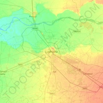
Naam: Topografische kaart Ludhiana, hoogte, reliëf.
Gemiddelde hoogte: 247 m
Minimale hoogte: 231 m
Maximale hoogte: 264 m
Ludhiana is located at 30°54′N 75°51′E / 30.9°N 75.85°E / 30.9; 75.85. It has an average elevation of 244 metres (801 ft). Ludhiana City, to its residents, consists of the Old City and the New City. The new city primarily consists of the Civil Lines area which was historically known as the residential and official quarters of the colonial British encampment.