
Topografische kaart Providence Island
Interactieve kaart
Klik op de kaart om de hoogte weer te geven.
Over deze kaart
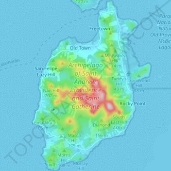
Naam: Topografische kaart Providence Island, hoogte, reliëf.
Gemiddelde hoogte: 33 m
Minimale hoogte: 0 m
Maximale hoogte: 345 m
Providencia's maximum elevation is 360 metres (1,180 ft) above sea level. The smaller Santa Catalina Island to the northwest is connected by a 100-metre (330 ft) footbridge to its larger sister Providencia Island. Providencia Island has an area of 17 square kilometres (6.6 sq mi); the two islands cover an area of 22 square kilometres (8.5 sq mi) and form the municipality of Santa Isabel, which had a population of 4,927 at the Census of 2005. The island is served by El Embrujo Airport, which the Colombian Government plans to expand in order to take international flights.