
Topografische kaart Warm Springs
Interactieve kaart
Klik op de kaart om de hoogte weer te geven.
Over deze kaart
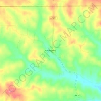
Naam: Topografische kaart Warm Springs, hoogte, reliëf.
Gemiddelde hoogte: 148 m
Minimale hoogte: 106 m
Maximale hoogte: 191 m
Andere topografische kaarten
Klik op een kaart om zijn topografie, zijn hoogte en zijn reliëf te bekijken.
Sand Hill
United States > Arkansas > Randolph County > Pocahontas
Sand Hill, Pocahontas, Randolph County, Arkansas, 72455, United States
Gemiddelde hoogte: 118 m
Maynard
United States > Arkansas > Randolph County
Maynard, Randolph County, Arkansas, 72444, United States
Gemiddelde hoogte: 128 m
O'Kean
United States > Arkansas > Randolph County
O'Kean, Randolph County, Arkansas, 72425, United States
Gemiddelde hoogte: 82 m
Pocahontas
United States > Arkansas > Randolph County > Pocahontas
Pocahontas, Randolph County, Arkansas, United States
Gemiddelde hoogte: 96 m
Pocahontas
United States > Arkansas > Randolph County > Pocahontas
Pocahontas, Randolph County, Arkansas, 72455, United States
Gemiddelde hoogte: 94 m
O"Kean
United States > Arkansas > Randolph County > O"Kean
O"Kean, Randolph County, Arkansas, 72425, United States
Gemiddelde hoogte: 82 m