
Doe een donatie
Rust jezelf uit voor je volgende avontuur:
Als Amazon-partner verdient deze site een commissie op in aanmerking komende aankopen, zonder extra kosten voor jou.
Topografische kaart Denman Island
Klik op de kaart om de hoogte weer te geven.
Doe een donatie
Rust jezelf uit voor je volgende avontuur:
Als Amazon-partner verdient deze site een commissie op in aanmerking komende aankopen, zonder extra kosten voor jou.
Over deze kaart
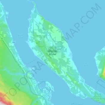
Naam: Topografische kaart Denman Island, hoogte, reliëf.
Gemiddelde hoogte: 36 m
Minimale hoogte: -1 m
Maximale hoogte: 581 m
Doe een donatie
Rust jezelf uit voor je volgende avontuur:
Als Amazon-partner verdient deze site een commissie op in aanmerking komende aankopen, zonder extra kosten voor jou.
Andere topografische kaarten
Klik op een kaart om zijn topografie, zijn hoogte en zijn reliëf te bekijken.
Union Bay
Canada > British Columbia > Comox Valley Regional District > Area A (Baynes Sound)
Gemiddelde hoogte: 39 m
Fanny Bay
Canada > British Columbia > Comox Valley Regional District > Area A (Baynes Sound)
Gemiddelde hoogte: 36 m
Royston
Canada > British Columbia > Comox Valley Regional District > Area A (Baynes Sound)
Gemiddelde hoogte: 29 m
Buckley Bay
Canada > British Columbia > Comox Valley Regional District > Area A (Baynes Sound)
Gemiddelde hoogte: 35 m
Doe een donatie
Rust jezelf uit voor je volgende avontuur:
Als Amazon-partner verdient deze site een commissie op in aanmerking komende aankopen, zonder extra kosten voor jou.
Beaufort Range
Canada > British Columbia > Comox Valley Regional District > Area A (Baynes Sound)
Gemiddelde hoogte: 435 m
Mount Curran
Canada > British Columbia > Comox Valley Regional District > Area A (Baynes Sound)
Gemiddelde hoogte: 1.142 m