
Topografische kaart Morrissey Provincial Park
Interactieve kaart
Klik op de kaart om de hoogte weer te geven.
Over deze kaart
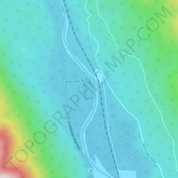
Naam: Topografische kaart Morrissey Provincial Park, hoogte, reliëf.
Gemiddelde hoogte: 1.040 m
Minimale hoogte: 944 m
Maximale hoogte: 1.558 m
Andere topografische kaarten
Klik op een kaart om zijn topografie, zijn hoogte en zijn reliëf te bekijken.
Barnes Lake
Canada > British Columbia > Regional District of East Kootenay > Area A (Upper Flathead/Elk Valley)
Barnes Lake, Area A (Upper Flathead/Elk Valley), Regional District of East Kootenay, British Columbia, Canada
Gemiddelde hoogte: 2.073 m
Mount Fernie Provincial Park
Canada > British Columbia > Regional District of East Kootenay > Area A (Upper Flathead/Elk Valley)
Mount Fernie Provincial Park, Area A (Upper Flathead/Elk Valley), Regional District of East Kootenay, British Columbia, Canada
Gemiddelde hoogte: 1.108 m
Island Lake
Canada > British Columbia > Regional District of East Kootenay > Area A (Upper Flathead/Elk Valley)
Island Lake, Area A (Upper Flathead/Elk Valley), Regional District of East Kootenay, British Columbia, Canada
Gemiddelde hoogte: 1.511 m
Mount Erickson
Canada > British Columbia > Regional District of East Kootenay > Area A (Upper Flathead/Elk Valley)
Mount Erickson, Area A (Upper Flathead/Elk Valley), Regional District of East Kootenay, British Columbia, Canada
Gemiddelde hoogte: 1.938 m
Grizzly Peak
Canada > British Columbia > Regional District of East Kootenay > Area A (Upper Flathead/Elk Valley)
Grizzly Peak, Area A (Upper Flathead/Elk Valley), Regional District of East Kootenay, British Columbia, V0B 1Y0, Canada
Gemiddelde hoogte: 1.962 m