
Doe een donatie
Rust jezelf uit voor je volgende avontuur:
Als Amazon-partner verdient deze site een commissie op in aanmerking komende aankopen, zonder extra kosten voor jou.
Topografische kaart Calw
Klik op de kaart om de hoogte weer te geven.
Doe een donatie
Rust jezelf uit voor je volgende avontuur:
Als Amazon-partner verdient deze site een commissie op in aanmerking komende aankopen, zonder extra kosten voor jou.
Calw
Calw is located in the valley of the Nagold in the Northern Black Forest at an altitude between 330 and 630 metres (1,080–2,070 ft) above sea level. The historic centre lies west of the river. The newer parts of town have developed on the surrounding slopes. The following streams also exist within the town: the Tälesbach, Ziegelbach, Wurstbrunnenbach, Schießbach, Schlittenbach und Schweinbach. In the northern part of the town, on the western slope of the Nagold valley is the cave known as the Bruderhöhle.
Doe een donatie
Rust jezelf uit voor je volgende avontuur:
Als Amazon-partner verdient deze site een commissie op in aanmerking komende aankopen, zonder extra kosten voor jou.
Over deze kaart
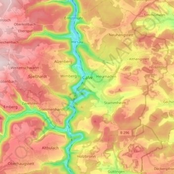
Naam: Topografische kaart Calw, hoogte, reliëf.
Gemiddelde hoogte: 540 m
Minimale hoogte: 324 m
Maximale hoogte: 701 m
Doe een donatie
Rust jezelf uit voor je volgende avontuur:
Als Amazon-partner verdient deze site een commissie op in aanmerking komende aankopen, zonder extra kosten voor jou.
Andere topografische kaarten
Klik op een kaart om zijn topografie, zijn hoogte en zijn reliëf te bekijken.
Zieflensberg
Germany > Baden-Württemberg > Landkreis Calw > Bad Herrenalb > Zieflensberg
Gemiddelde hoogte: 668 m
Bad Teinach
Germany > Baden-Württemberg > Landkreis Calw
The township (Stadt) of Bad Teinach-Zavelstein is located at the center of the district of Calw, in Baden-Württemberg, one of the 16 States of the Federal Republic of Germany. Bad Teinach-Zavelstein's municipal area rests upon the plateau of the Enz and Nagold rivers, a landscape defined by severe river…
Gemiddelde hoogte: 557 m
Doe een donatie
Rust jezelf uit voor je volgende avontuur:
Als Amazon-partner verdient deze site een commissie op in aanmerking komende aankopen, zonder extra kosten voor jou.