
Topografische kaart Heirhill
Interactieve kaart
Klik op de kaart om de hoogte weer te geven.
Over deze kaart
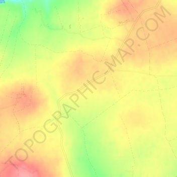
Naam: Topografische kaart Heirhill, hoogte, reliëf.
Gemiddelde hoogte: 54 m
Minimale hoogte: 0 m
Maximale hoogte: 86 m
Andere topografische kaarten
Klik op een kaart om zijn topografie, zijn hoogte en zijn reliëf te bekijken.
Ballyseedy Wood
Ballyseedy Wood, Ballyseedy ED, Tralee Municipal District, County Kerry, Munster, Ireland
Gemiddelde hoogte: 20 m
Shronowen
Shronowen, Shronowen ED, Listowel Municipal District, County Kerry, Munster, Ireland
Gemiddelde hoogte: 27 m
Torc Mountain
Torc Mountain, Killarney Municipal District, County Kerry, Munster, V93 RR59, Ireland
Gemiddelde hoogte: 202 m
Lisselton
Lisselton, Listowel Municipal District, County Kerry, Munster, Ireland
Gemiddelde hoogte: 34 m
Farranfore
Farranfore, Tralee Municipal District, County Kerry, Munster, V93 YP44, Ireland
Gemiddelde hoogte: 59 m
Stradbally Mountain
Stradbally Mountain, Kenmare Municipal District, County Kerry, Munster, Ireland
Gemiddelde hoogte: 487 m
Glencar
Glencar, Kenmare Municipal District, County Kerry, Munster, Ireland
Gemiddelde hoogte: 114 m
Cahersiveen
Cahersiveen, County Kerry, Munster, V23 FF95, Ireland
Gemiddelde hoogte: 66 m
Kilgarvan
Kilgarvan, Kilgarvan ED, Kenmare Municipal District, County Kerry, Munster, Ireland
Gemiddelde hoogte: 71 m
Brosna
Brosna, Tralee Municipal District, County Kerry, Munster, Ireland
Gemiddelde hoogte: 163 m
Killarney
Killarney, Killarney Municipal District, County Kerry, Munster, Ireland
Gemiddelde hoogte: 57 m
Rathmore
Rathmore, Rathmore ED, Killarney Municipal District, County Kerry, Munster, P51 PT66, Ireland
Gemiddelde hoogte: 149 m
Lispole
Lispole, Kenmare Municipal District, County Kerry, Munster, V92 DN23, Ireland
Gemiddelde hoogte: 107 m
Kilcummin
Kilcummin, Kilcummin ED, Killarney Municipal District, County Kerry, Munster, Ireland
Gemiddelde hoogte: 142 m
Cromane Upper
Cromane Upper, Killorglin ED, Kenmare Municipal District, County Kerry, Munster, Ireland
Gemiddelde hoogte: 18 m
Killorglin
Killorglin, Killorglin ED, Kenmare Municipal District, County Kerry, Munster, Ireland
Gemiddelde hoogte: 23 m
Lyreboy
Lyreboy, Maum ED, Kenmare Municipal District, County Kerry, Munster, Ireland
Gemiddelde hoogte: 342 m
Killarney
Killarney, Killarney Urban ED, Killarney Municipal District, County Kerry, Munster, Ireland
Gemiddelde hoogte: 39 m
Glenmore
Glenmore, Glanmore ED, Kenmare Municipal District, County Kerry, Munster, Ireland
Gemiddelde hoogte: 269 m
Glanmore
Glanmore, Kilgobban ED, Kenmare Municipal District, County Kerry, Munster, Ireland
Gemiddelde hoogte: 187 m
Beheenagh
Beheenagh, Kilgobban ED, Kenmare Municipal District, County Kerry, Munster, Ireland
Gemiddelde hoogte: 347 m
Banna Strand
Banna Strand, Banna ED, Tralee Municipal District, County Kerry, Munster, Ireland
Gemiddelde hoogte: 4 m
Lauragh
Lauragh, Kenmare Municipal District, County Kerry, Munster, Ireland
Gemiddelde hoogte: 89 m
Killarney
Ireland > County Kerry > Killarney
Killarney, Killarney Municipal District, County Kerry, Munster, V93 AYP9, Ireland
Gemiddelde hoogte: 66 m
Glashanacree
Glashanacree, Kilshenane ED, Tralee Municipal District, County Kerry, Munster, Ireland
Gemiddelde hoogte: 143 m
Derrybanane
Derrybanane, Flesk ED, Killarney Municipal District, County Kerry, Munster, Ireland
Gemiddelde hoogte: 299 m
Valencia Island
Valencia Island, Kenmare Municipal District, County Kerry, Munster, Ireland
Gemiddelde hoogte: 39 m
Barrow
Barrow, Ballynahaglish ED, Tralee Municipal District, County Kerry, Munster, Ireland
Gemiddelde hoogte: 7 m
Lough Guitane
Lough Guitane, Flesk ED, Killarney Municipal District, County Kerry, Munster, Ireland
Gemiddelde hoogte: 112 m
Knoppoge
Knoppoge, Ballyduff ED, Listowel Municipal District, County Kerry, Munster, Ireland
Gemiddelde hoogte: 29 m
Gunsborough
Gunsborough, Gunsborough ED, Listowel Municipal District, County Kerry, Munster, V31 TR74, Ireland
Gemiddelde hoogte: 54 m
Barraduff
Ireland > County Kerry > Barraduff
Barraduff, Killarney Municipal District, County Kerry, Munster, Ireland
Gemiddelde hoogte: 124 m
Knocknacree
Knocknacree, Ballyduff ED, Listowel Municipal District, County Kerry, Munster, Ireland
Gemiddelde hoogte: 51 m
Pallis
Pallis, Lahard ED, Killarney Municipal District, County Kerry, Munster, Ireland
Gemiddelde hoogte: 48 m
Ballincolla
Ballincolla, Dunurlin ED, Kenmare Municipal District, County Kerry, Munster, Ireland
Gemiddelde hoogte: 22 m
Rattoo Round Tower
Rattoo Round Tower, R551, Ballyduff ED, Listowel Municipal District, County Kerry, Munster, Ireland
Gemiddelde hoogte: 16 m
Knockbrack
Knockbrack, Ballynorig ED, Listowel Municipal District, County Kerry, Munster, Ireland
Gemiddelde hoogte: 20 m
Raheens
Raheens, Bahaghs ED, Kenmare Municipal District, County Kerry, Munster, Ireland
Gemiddelde hoogte: 166 m
Ballintobernig
Ballintobernig, Ratass ED, Tralee Municipal District, County Kerry, Munster, Ireland
Gemiddelde hoogte: 182 m
Castlelough
Castlelough, Muckross ED, Killarney Municipal District, County Kerry, Munster, V93 RR59, Ireland
Gemiddelde hoogte: 35 m
Ballydunlea
Ballydunlea, Tralee Rural ED, Tralee Municipal District, County Kerry, Munster, Ireland
Gemiddelde hoogte: 158 m
Drombeg
Drombeg, Shronowen ED, Listowel Municipal District, County Kerry, Munster, Ireland
Gemiddelde hoogte: 43 m
Knockglass Beg
Knockglass Beg, Knockglass ED, Kenmare Municipal District, County Kerry, Munster, Ireland
Gemiddelde hoogte: 94 m
Ballyconnell
Ballyconnell, Kilfeighny ED, Listowel Municipal District, County Kerry, Munster, Ireland
Gemiddelde hoogte: 41 m
Coolroe Upper
Coolroe Upper, Glanbehy ED, Kenmare Municipal District, County Kerry, Munster, Ireland
Gemiddelde hoogte: 178 m
Cahernageeha
Cahernageeha, Darrynane ED, Kenmare Municipal District, County Kerry, Munster, Ireland
Gemiddelde hoogte: 223 m