
Topografische kaart Benge Corner
Interactieve kaart
Klik op de kaart om de hoogte weer te geven.
Over deze kaart
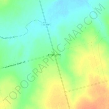
Naam: Topografische kaart Benge Corner, hoogte, reliëf.
Locatie: Benge Corner, Midland County, Texas, United States (31.69402 -102.02986 31.73402 -101.98986)
Gemiddelde hoogte: 833 m
Minimale hoogte: 815 m
Maximale hoogte: 855 m
Andere topografische kaarten
Klik op een kaart om zijn topografie, zijn hoogte en zijn reliëf te bekijken.
Midland
United States > Texas > Midland County
Midland, Midland County, Texas, United States
Gemiddelde hoogte: 855 m
Estes
United States > Texas > Midland County
Estes, Midland County, Texas, United States
Gemiddelde hoogte: 862 m
Spraberry
United States > Texas > Midland County
Spraberry, Midland County, Texas, United States
Gemiddelde hoogte: 805 m
drainage
United States > Texas > Midland County > Midland
drainage, Tanglewood, Midland, Midland County, Texas, United States
Gemiddelde hoogte: 850 m
Bounce
United States > Texas > Midland County > Midland
Bounce, Midland, Midland County, Texas, 79712, United States
Gemiddelde hoogte: 872 m