
Doe een donatie
Rust jezelf uit voor je volgende avontuur:
Als Amazon-partner verdient deze site een commissie op in aanmerking komende aankopen, zonder extra kosten voor jou.
Topografische kaart Sawtooth Range
Klik op de kaart om de hoogte weer te geven.
Doe een donatie
Rust jezelf uit voor je volgende avontuur:
Als Amazon-partner verdient deze site een commissie op in aanmerking komende aankopen, zonder extra kosten voor jou.
Sawtooth Range
The Sawtooth Range is a mountain range of the Rocky Mountains in central Idaho, United States, reaching a maximum elevation of 10,751 feet (3,277 m) at the summit of Thompson Peak. It encompasses an area of 678 square miles (1,756 km2) spanning parts of Custer, Boise, Blaine, and Elmore counties, and is bordered to the east by the Sawtooth Valley. Much of the mountain range is within the Sawtooth Wilderness, part of the Sawtooth National Recreation Area and Sawtooth National Forest.
Doe een donatie
Rust jezelf uit voor je volgende avontuur:
Als Amazon-partner verdient deze site een commissie op in aanmerking komende aankopen, zonder extra kosten voor jou.
Over deze kaart
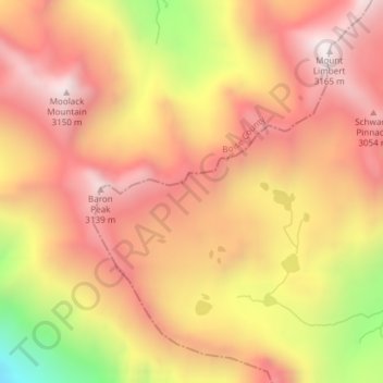
Naam: Topografische kaart Sawtooth Range, hoogte, reliëf.
Locatie: Sawtooth Range, Custer County, Idaho, United States (44.12303 -115.03752 44.12313 -115.03742)
Gemiddelde hoogte: 2.761 m
Minimale hoogte: 2.079 m
Maximale hoogte: 3.151 m
Doe een donatie
Rust jezelf uit voor je volgende avontuur:
Als Amazon-partner verdient deze site een commissie op in aanmerking komende aankopen, zonder extra kosten voor jou.
Andere topografische kaarten
Klik op een kaart om zijn topografie, zijn hoogte en zijn reliëf te bekijken.
Mackay
United States > Idaho > Custer County
Mackay is located at 43°54′43″N 113°36′49″W / 43.91194°N 113.61361°W / 43.91194; -113.61361 (43.911880, -113.613669), at an elevation of 5,905 feet (1,800 m).
Gemiddelde hoogte: 1.811 m
Stanley
United States > Idaho > Custer County
Stanley is located at 44°13′0″N 114°56′16″W / 44.21667°N 114.93778°W / 44.21667; -114.93778 (44.216698, -114.937814), at an elevation of 6,253 feet (1,906 m) above sea level
Gemiddelde hoogte: 1.931 m
Challis
United States > Idaho > Custer County
Challis is located at 44°30′15″N 114°13′42″W / 44.50417°N 114.22833°W / 44.50417; -114.22833 (44.504260, -114.228279), at an elevation of 5,253 feet (1,601 m) above sea level.
Gemiddelde hoogte: 1.626 m
Doe een donatie
Rust jezelf uit voor je volgende avontuur:
Als Amazon-partner verdient deze site een commissie op in aanmerking komende aankopen, zonder extra kosten voor jou.
Edith Lake
United States > Idaho > Custer County
With a surface elevation of 8,660 feet (2,640 m) above sea level, Sawtooth Lake often remains frozen into early summer.
Gemiddelde hoogte: 2.688 m
Stanley
United States > Idaho > Custer County
In latitude and elevation, Stanley's weather station is a near-perfect twin of the station at the summit of Mt. Washington in New Hampshire. But although both are quite cold, their climates are very different.
Gemiddelde hoogte: 1.931 m
Doe een donatie
Rust jezelf uit voor je volgende avontuur:
Als Amazon-partner verdient deze site een commissie op in aanmerking komende aankopen, zonder extra kosten voor jou.
Mackay
United States > Idaho > Custer County
Mackay is located at 43°54′43″N 113°36′49″W / 43.91194°N 113.61361°W / 43.91194; -113.61361 (43.911880, -113.613669), at an elevation of 5,905 feet (1,800 m).
Gemiddelde hoogte: 1.811 m
Doe een donatie
Rust jezelf uit voor je volgende avontuur:
Als Amazon-partner verdient deze site een commissie op in aanmerking komende aankopen, zonder extra kosten voor jou.
Redfish Lake
United States > Idaho > Custer County
The surface elevation of Redfish Lake is 6,547 feet (1,996 m) above sea level. The lake is 4.5 miles (7.2 km) long and 0.72 miles (1.2 km) wide, with a maximum depth of 387 feet (118 m), and 11 miles (18 km) of shoreline. The actual trail around the lake is 17.5 miles (28 km) in length.
Gemiddelde hoogte: 2.144 m