
Topografische kaart Champ la rue
Interactieve kaart
Klik op de kaart om de hoogte weer te geven.
Over deze kaart
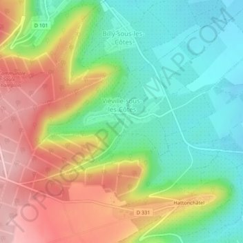
Naam: Topografische kaart Champ la rue, hoogte, reliëf.
Gemiddelde hoogte: 309 m
Minimale hoogte: 237 m
Maximale hoogte: 407 m
Andere topografische kaarten
Klik op een kaart om zijn topografie, zijn hoogte en zijn reliëf te bekijken.
Grèves
France > Grand Est > Vigneulles-lès-Hattonchâtel
Grèves, Vigneulles-lès-Hattonchâtel, Commercy, Meuse, Grand Est, France métropolitaine, 55210, France
Gemiddelde hoogte: 309 m
Woëvre
France > Grand Est > Vigneulles-lès-Hattonchâtel
Woëvre, Creuë, Vigneulles-lès-Hattonchâtel, Commercy, Meuse, Grand Est, France métropolitaine, 55210, France
Gemiddelde hoogte: 242 m
Les oignons
France > Grand Est > Vigneulles-lès-Hattonchâtel
Les oignons, Billy-sous-les-Côtes, Vigneulles-lès-Hattonchâtel, Commercy, Meuse, Grand Est, France métropolitaine, 55210, France
Gemiddelde hoogte: 254 m
L'Yron
France > Grand Est > Vigneulles-lès-Hattonchâtel
L'Yron, Vigneulles-lès-Hattonchâtel, Commercy, Meuse, Grand Est, France métropolitaine, 55210, France
Gemiddelde hoogte: 224 m
Creuë
France > Grand Est > Vigneulles-lès-Hattonchâtel
Creuë, Vigneulles-lès-Hattonchâtel, Commercy, Meuse, Grand Est, France métropolitaine, 55210, France
Gemiddelde hoogte: 315 m