

Topografische kaart Spences Bridge
Klik op de kaart om de hoogte weer te geven.
Spences Bridge
Spences Bridge's location is mountainous, with higher elevations part of the Interior Plateau. The east side of the Fraser here is part of the Clear Range, a mountainous southwards extension of the Fraser Plateau located in the angle of the Thompson and Fraser Rivers. Arthur Seat lies in that range on the west side of Spences Bridge, and was named by pioneer John Murray for Arthur's Seat in Edinburgh, Scotland.
Over deze kaart
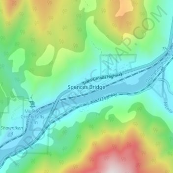
Naam: Topografische kaart Spences Bridge, hoogte, reliëf.
Gemiddelde hoogte: 496 m
Minimale hoogte: 213 m
Maximale hoogte: 1.195 m
Andere topografische kaarten
Klik op een kaart om zijn topografie, zijn hoogte en zijn reliëf te bekijken.
Barnes Lake
Canada > British Columbia > Thompson-Nicola Regional District > Area I (Blue Sky Country)
Gemiddelde hoogte: 752 m
Walhachin
Canada > British Columbia > Thompson-Nicola Regional District > Area I (Blue Sky Country)
In December 1914, the westward advance of the CNoR rail head from Kamloops reached Walhachin. The track follows the valley floor at a much lower elevation than the hamlet proper.
Gemiddelde hoogte: 438 m
Blue Earth Lake
Canada > British Columbia > Thompson-Nicola Regional District > Area I (Blue Sky Country)
Gemiddelde hoogte: 1.525 m