
Topografische kaart Big Bend National Park
Interactieve kaart
Klik op de kaart om de hoogte weer te geven.
Over deze kaart
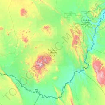
Naam: Topografische kaart Big Bend National Park, hoogte, reliëf.
Gemiddelde hoogte: 934 m
Minimale hoogte: 486 m
Maximale hoogte: 2.330 m
Big Bend National Park is an American national park located in West Texas, bordering Mexico. The park has national significance as the largest protected area of Chihuahuan Desert topography and ecology in the United States. The park protects more than 1,200 species of plants, more than 450 species of birds, 56 species of reptiles, and 75 species of mammals.