
Topografische kaart Sarles
Interactieve kaart
Klik op de kaart om de hoogte weer te geven.
Over deze kaart
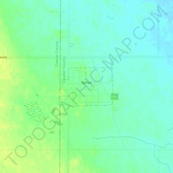
Naam: Topografische kaart Sarles, hoogte, reliëf.
Locatie: Sarles, Cavalier County, North Dakota, United States (48.94218 -99.00256 48.94819 -98.98969)
Gemiddelde hoogte: 483 m
Minimale hoogte: 476 m
Maximale hoogte: 493 m
Andere topografische kaarten
Klik op een kaart om zijn topografie, zijn hoogte en zijn reliëf te bekijken.
Langdon
United States > North Dakota > Cavalier County
Langdon, Cavalier County, North Dakota, United States
Gemiddelde hoogte: 492 m
Calio
United States > North Dakota > Cavalier County
Calio, Cavalier County, North Dakota, United States
Gemiddelde hoogte: 474 m
Alsen
United States > North Dakota > Cavalier County
Alsen, Cavalier County, North Dakota, United States
Gemiddelde hoogte: 481 m
Milton
United States > North Dakota > Cavalier County
Milton, Cavalier County, North Dakota, United States
Gemiddelde hoogte: 480 m
Munich
United States > North Dakota > Cavalier County
Munich, Cavalier County, North Dakota, United States
Gemiddelde hoogte: 487 m
Calvin
United States > North Dakota > Cavalier County
Calvin, Cavalier County, North Dakota, United States
Gemiddelde hoogte: 492 m
Loma
United States > North Dakota > Cavalier County
Loma, Cavalier County, North Dakota, United States
Gemiddelde hoogte: 480 m
Osnabrock
United States > North Dakota > Cavalier County
Osnabrock, Cavalier County, North Dakota, United States
Gemiddelde hoogte: 494 m
Nekoma
United States > North Dakota > Cavalier County
Nekoma, Cavalier County, North Dakota, 58355, United States
Gemiddelde hoogte: 495 m
Hannah
United States > North Dakota > Cavalier County
Hannah, Cavalier County, North Dakota, United States
Gemiddelde hoogte: 476 m
Wales
United States > North Dakota > Cavalier County
Wales, Cavalier County, North Dakota, United States
Gemiddelde hoogte: 477 m