
Topografische kaart Lake Bullen Merri
Interactieve kaart
Klik op de kaart om de hoogte weer te geven.
Over deze kaart
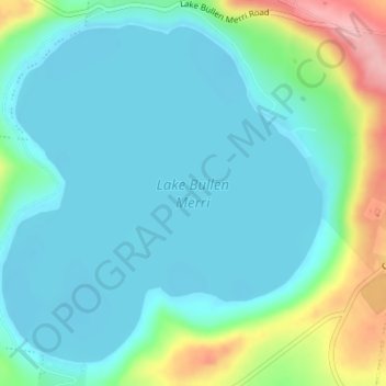
Naam: Topografische kaart Lake Bullen Merri, hoogte, reliëf.
Gemiddelde hoogte: 171 m
Minimale hoogte: 139 m
Maximale hoogte: 281 m
The smaller lake to the north of Lake Bullen Merri has a maximum depth of 20 m (66 ft). The two lakes are linked by an overflow channel in the common wall at an elevation of 175 m. There is a 19th-century record of water from Bullen Merri overflowing into Gnotuk.
Andere topografische kaarten
Klik op een kaart om zijn topografie, zijn hoogte en zijn reliëf te bekijken.
Mount Sugarloaf
Australia > Victoria > Camperdown
Mount Sugarloaf, Camperdown, Shire of Corangamite, Victoria, 3260, Australia
Gemiddelde hoogte: 201 m
Camperdown
Australia > Victoria > Camperdown
Camperdown, Shire of Corangamite, Barwon South West, Victoria, 3260, Australia
Gemiddelde hoogte: 170 m