
Topografische kaart Kottayam
Interactieve kaart
Klik op de kaart om de hoogte weer te geven.
Kottayam
Kottayam has an average elevation of 3 metres (9.8 ft) above sea level. and is situated in the basin of the Meenachil River and in the basin of the Vembanad backwaters, which are formed from several streams in the Western Ghats in Idukki district. According to the division of places in Kerala based on altitudes, Kottayam is classified as being a midland area. The general soil type is alluvial soil. The vegetation is mainly tropical evergreen and moist deciduous type.
Over deze kaart
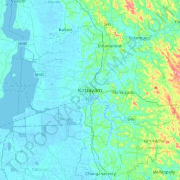
Naam: Topografische kaart Kottayam, hoogte, reliëf.
Locatie: Kottayam, Kottayam District, Kerala, 686001, India (9.43156 76.36216 9.75156 76.68216)
Gemiddelde hoogte: 19 m
Minimale hoogte: -4 m
Maximale hoogte: 157 m
Andere topografische kaarten
Klik op een kaart om zijn topografie, zijn hoogte en zijn reliëf te bekijken.