
Topografische kaart Muthill
Interactieve kaart
Klik op de kaart om de hoogte weer te geven.
Over deze kaart
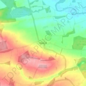
Naam: Topografische kaart Muthill, hoogte, reliëf.
Locatie: Muthill, Perth and Kinross, Scotland, PH5 2AW, United Kingdom (56.31176 -3.85346 56.35176 -3.81346)
Gemiddelde hoogte: 85 m
Minimale hoogte: 25 m
Maximale hoogte: 162 m
Andere topografische kaarten
Klik op een kaart om zijn topografie, zijn hoogte en zijn reliëf te bekijken.
Culteuchar
United Kingdom > Scotland > Perth and Kinross > Perth
Culteuchar, Perth, Perth and Kinross, Scotland, PH2 9HL, United Kingdom
Gemiddelde hoogte: 194 m
Bridge of Earn
United Kingdom > Scotland > Perth and Kinross
Bridge of Earn, Perth and Kinross, Scotland, PH2 9PL, United Kingdom
Gemiddelde hoogte: 70 m
Blairgowrie and Rattray
United Kingdom > Scotland > Perth and Kinross
Blairgowrie and Rattray, Perth and Kinross, Scotland, PH10 6AB, United Kingdom
Gemiddelde hoogte: 121 m
Wolfhill
United Kingdom > Scotland > Perth and Kinross
Wolfhill, Perth and Kinross, Scotland, PH2 6TH, United Kingdom
Gemiddelde hoogte: 118 m
Forgandenny
United Kingdom > Scotland > Perth and Kinross
Forgandenny, Perth and Kinross, Scotland, PH2 9EQ, United Kingdom
Gemiddelde hoogte: 53 m