
Topografische kaart Lafayette
Interactieve kaart
Klik op de kaart om de hoogte weer te geven.
Over deze kaart
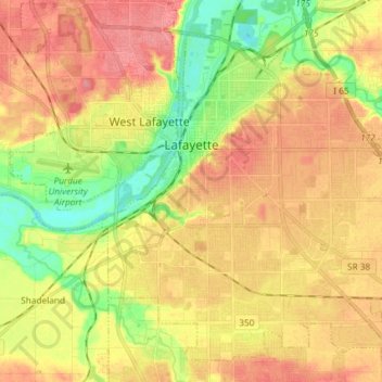
Naam: Topografische kaart Lafayette, hoogte, reliëf.
Locatie: Lafayette, Tippecanoe County, Indiana, United States (40.35549 -86.92611 40.45305 -86.79032)
Gemiddelde hoogte: 193 m
Minimale hoogte: 152 m
Maximale hoogte: 224 m
Lafayette is located at 40°24′38″N 86°52′29″W / 40.410585°N 86.874681°W / 40.410585; -86.874681 (40.410585, −86.874681) and is located in Fairfield and Wea Townships. Elevation at the court house is 550 feet (168 m), but city elevations range from a little over 500 feet (150 m) at the Wabash River to approximately 700 feet (210 m) in the areas of Murdock Park and Columbian Park.
Andere topografische kaarten
Klik op een kaart om zijn topografie, zijn hoogte en zijn reliëf te bekijken.
West Lafayette
United States > Indiana > Tippecanoe County
West Lafayette, Tippecanoe County, Indiana, United States
Gemiddelde hoogte: 192 m
Burnett's Creek
United States > Indiana > Tippecanoe County > Battle Ground
Burnett's Creek, Battle Ground, Tippecanoe County, Indiana, United States
Gemiddelde hoogte: 179 m
Battle Ground
United States > Indiana > Tippecanoe County
Battle Ground, Tippecanoe County, Indiana, United States
Gemiddelde hoogte: 180 m
Altamont Switch
United States > Indiana > Tippecanoe County > Lafayette
Altamont Switch, Lafayette, Tippecanoe County, Indiana, 47909, United States
Gemiddelde hoogte: 197 m
Buck Creek
United States > Indiana > Tippecanoe County
Buck Creek, Tippecanoe County, Indiana, 47924, United States
Gemiddelde hoogte: 202 m
West Point
United States > Indiana > Tippecanoe County
West Point, Tippecanoe County, Indiana, 47992, United States
Gemiddelde hoogte: 198 m