
Doe een donatie
Rust jezelf uit voor je volgende avontuur:
Als Amazon-partner verdient deze site een commissie op in aanmerking komende aankopen, zonder extra kosten voor jou.
Topografische kaart Pittston
Klik op de kaart om de hoogte weer te geven.
Doe een donatie
Rust jezelf uit voor je volgende avontuur:
Als Amazon-partner verdient deze site een commissie op in aanmerking komende aankopen, zonder extra kosten voor jou.
Pittston
The city can be divided into three sections: the Oregon Section (located in southern Pittston), the Downtown (or City Center), and the Junction (or Upper Pittston). The Oregon Section is a neighborhood located on high ground overlooking the Susquehanna River (in the southern half of the city). The Downtown is located to the north (in the central part of Pittston). U.S. Route 11 passes through this part of the city. Two bridges cross over the Susquehanna and connect the Downtown with the Borough of West Pittston (on the opposite bank). The Downtown is where most of the city's businesses and high-rises exist. The elevation climbs as you move inland (eastward) away from the Susquehanna. The northernmost section of the city is known as the Junction. It is named after the railroad junction (or the Duryea Yard) which runs through its borders. It consists mostly of suburbs built upon several steep hills which overlook both the Susquehanna and Lackawanna Rivers. The Lackawanna River makes up Pittston's northern border.
Doe een donatie
Rust jezelf uit voor je volgende avontuur:
Als Amazon-partner verdient deze site een commissie op in aanmerking komende aankopen, zonder extra kosten voor jou.
Over deze kaart
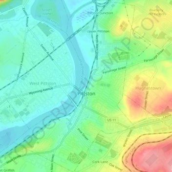
Naam: Topografische kaart Pittston, hoogte, reliëf.
Locatie: Pittston, Luzerne County, Pennsylvania, United States (41.31054 -75.80928 41.34418 -75.77665)
Gemiddelde hoogte: 197 m
Minimale hoogte: 159 m
Maximale hoogte: 276 m
Doe een donatie
Rust jezelf uit voor je volgende avontuur:
Als Amazon-partner verdient deze site een commissie op in aanmerking komende aankopen, zonder extra kosten voor jou.
Andere topografische kaarten
Klik op een kaart om zijn topografie, zijn hoogte en zijn reliëf te bekijken.
Ricketts Glen State Park
United States > Pennsylvania > Luzerne County > Fairmount Township
The state's original plans for the new park included building an inn, an 18-hole golf course and country club, and a winter sports complex for skiing, ice boating, and tobogganing, as well as a beach with bathing facilities, cabins, and a tent camping area. Only the last three were actually built, all south of…
Gemiddelde hoogte: 588 m
Doe een donatie
Rust jezelf uit voor je volgende avontuur:
Als Amazon-partner verdient deze site een commissie op in aanmerking komende aankopen, zonder extra kosten voor jou.
Wapwallopen
United States > Pennsylvania > Luzerne County > Conyngham Township
Gemiddelde hoogte: 223 m
Doe een donatie
Rust jezelf uit voor je volgende avontuur:
Als Amazon-partner verdient deze site een commissie op in aanmerking komende aankopen, zonder extra kosten voor jou.
Town Hill
United States > Pennsylvania > Luzerne County > Huntington Township
Gemiddelde hoogte: 281 m
Roaring Brook
United States > Pennsylvania > Luzerne County > Hunlock Township
Gemiddelde hoogte: 337 m
Doe een donatie
Rust jezelf uit voor je volgende avontuur:
Als Amazon-partner verdient deze site een commissie op in aanmerking komende aankopen, zonder extra kosten voor jou.
Fern Glen
United States > Pennsylvania > Luzerne County > Black Creek Township
Gemiddelde hoogte: 391 m
Doe een donatie
Rust jezelf uit voor je volgende avontuur:
Als Amazon-partner verdient deze site een commissie op in aanmerking komende aankopen, zonder extra kosten voor jou.
Doe een donatie
Rust jezelf uit voor je volgende avontuur:
Als Amazon-partner verdient deze site een commissie op in aanmerking komende aankopen, zonder extra kosten voor jou.
Liewellyn Corners
United States > Pennsylvania > Luzerne County > Bear Creek Township
Gemiddelde hoogte: 449 m
Wapwallopen
United States > Pennsylvania > Luzerne County > Conyngham Township
Gemiddelde hoogte: 223 m
Glen Summit
United States > Pennsylvania > Luzerne County > Fairview Township
Gemiddelde hoogte: 539 m
Doe een donatie
Rust jezelf uit voor je volgende avontuur:
Als Amazon-partner verdient deze site een commissie op in aanmerking komende aankopen, zonder extra kosten voor jou.
Doe een donatie
Rust jezelf uit voor je volgende avontuur:
Als Amazon-partner verdient deze site een commissie op in aanmerking komende aankopen, zonder extra kosten voor jou.
Hunlock Creek
United States > Pennsylvania > Luzerne County > Hunlock Township > Hunlock
Gemiddelde hoogte: 276 m
Huntington Mills
United States > Pennsylvania > Luzerne County > Huntington Township
Gemiddelde hoogte: 289 m
Doe een donatie
Rust jezelf uit voor je volgende avontuur:
Als Amazon-partner verdient deze site een commissie op in aanmerking komende aankopen, zonder extra kosten voor jou.
Doe een donatie
Rust jezelf uit voor je volgende avontuur:
Als Amazon-partner verdient deze site een commissie op in aanmerking komende aankopen, zonder extra kosten voor jou.
Fern Glen
United States > Pennsylvania > Luzerne County > Black Creek Township
Gemiddelde hoogte: 391 m
South Pond Dam
United States > Pennsylvania > Luzerne County > Hanover Township
Gemiddelde hoogte: 204 m
Doe een donatie
Rust jezelf uit voor je volgende avontuur:
Als Amazon-partner verdient deze site een commissie op in aanmerking komende aankopen, zonder extra kosten voor jou.