
Topografische kaart Epirus
Interactieve kaart
Klik op de kaart om de hoogte weer te geven.
Over deze kaart
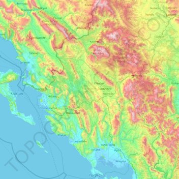
Naam: Topografische kaart Epirus, hoogte, reliëf.
Locatie: Epirus, Epirus - West-Macedonië, Griekenland (38.92305 19.98922 40.37660 21.43002)
Gemiddelde hoogte: 603 m
Minimale hoogte: -5 m
Maximale hoogte: 2.592 m
Andere topografische kaarten
Klik op een kaart om zijn topografie, zijn hoogte en zijn reliëf te bekijken.
Πάργα
Griekenland > Epirus - West-Macedonië > Περιφερειακή Ενότητα Πρέβεζας
Πάργα, Δήμος Πάργας, Περιφερειακή Ενότητα Πρέβεζας, Epirus, Epirus - West-Macedonië, 480 60, Griekenland
Gemiddelde hoogte: 177 m
Ιωάννινα
Griekenland > Epirus - West-Macedonië > Περιφερειακή Ενότητα Ιωαννίνων
Ιωάννινα, Δήμος Ιωαννιτών, Περιφερειακή Ενότητα Ιωαννίνων, Epirus, Epirus - West-Macedonië, 265 10, Griekenland
Gemiddelde hoogte: 724 m
Florina
Griekenland > Epirus - West-Macedonië > Περιφερεική Ενότητα Φλώρινας > Florina
Florina, Δήμος Φλώρινας, Περιφερεική Ενότητα Φλώρινας, West-Macedonië, Epirus - West-Macedonië, 53100, Griekenland
Gemiddelde hoogte: 1.008 m
Μέτσοβο
Griekenland > Epirus - West-Macedonië > Μέτσοβο
Μέτσοβο, Δήμος Μετσόβου, Περιφερειακή Ενότητα Ιωαννίνων, Epirus, Epirus - West-Macedonië, 44200, Griekenland
Gemiddelde hoogte: 1.318 m
Πάπιγκο
Griekenland > Epirus - West-Macedonië > Πάπιγκο
Πάπιγκο, Δήμος Ζαγορίου, Περιφερειακή Ενότητα Ιωαννίνων, Epirus, Epirus - West-Macedonië, 44016, Griekenland
Gemiddelde hoogte: 1.070 m
Άγναντα
Griekenland > Epirus - West-Macedonië > Περιφερειακή Ενότητα Άρτας
Άγναντα, Δήμος Κεντρικών Τζουμέρκων, Περιφερειακή Ενότητα Άρτας, Epirus, Epirus - West-Macedonië, 470 43, Griekenland
Gemiddelde hoogte: 751 m