
Topografische kaart Waxahachie
Interactieve kaart
Klik op de kaart om de hoogte weer te geven.
Over deze kaart
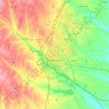
Naam: Topografische kaart Waxahachie, hoogte, reliëf.
Locatie: Waxahachie, Ellis County, Texas, 75165, United States (32.31442 -96.96361 32.49495 -96.74421)
Gemiddelde hoogte: 185 m
Minimale hoogte: 134 m
Maximale hoogte: 238 m
Andere topografische kaarten
Klik op een kaart om zijn topografie, zijn hoogte en zijn reliëf te bekijken.
Midlothian
United States > Texas > Ellis County
Midlothian, Ellis County, Texas, 76065, United States
Gemiddelde hoogte: 212 m
Italy
United States > Texas > Ellis County
Italy, Ellis County, Texas, 76651, United States
Gemiddelde hoogte: 173 m
Ennis
United States > Texas > Ellis County
Ennis, Ellis County, Texas, 75119, United States
Gemiddelde hoogte: 136 m
Five Points
United States > Texas > Ellis County
Five Points, Ellis County, Texas, 76041, United States
Gemiddelde hoogte: 178 m
Milford
United States > Texas > Ellis County > Milford
Milford, Ellis County, Texas, United States
Gemiddelde hoogte: 187 m
Ferris
United States > Texas > Ellis County > Ferris > Ferris
Ferris, Ellis County, Texas, 76125, United States
Gemiddelde hoogte: 136 m
Bristol
United States > Texas > Ellis County > Bristol
Bristol, Ellis County, Texas, United States
Gemiddelde hoogte: 139 m
Palmer
United States > Texas > Ellis County
Palmer, Ellis County, Texas, United States
Gemiddelde hoogte: 135 m
Red Oak
United States > Texas > Ellis County
Red Oak, Ellis County, Texas, 75154, United States
Gemiddelde hoogte: 181 m
Maypearl
United States > Texas > Ellis County
Maypearl, Ellis County, Texas, United States
Gemiddelde hoogte: 175 m