
Topografische kaart Kurnool
Klik op de kaart om de hoogte weer te geven.
Kurnool
Kurnool is located at 15°50′00″N 78°03′00″E / 15.8333°N 78.05°E / 15.8333; 78.05. It has an average elevation of 273 metres (898 feet). Kurnool lies on the banks of the Tungabhadra River. The Hundri and Neeva rivers also flow through the city. The K.C.Canal (Kurnool–Cuddapah) was built by the Dutch for transportation, but later used for irrigation.
Over deze kaart
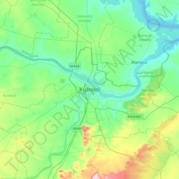
Naam: Topografische kaart Kurnool, hoogte, reliëf.
Locatie: Kurnool, Andhra Pradesh, 518001, India (15.67093 77.88254 15.99093 78.20254)
Gemiddelde hoogte: 307 m
Minimale hoogte: 259 m
Maximale hoogte: 453 m