
Topografische kaart Champlain
Klik op de kaart om de hoogte weer te geven.
Over deze kaart
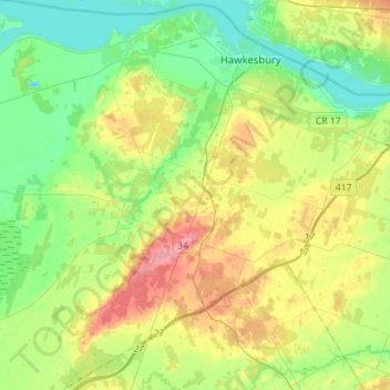
Naam: Topografische kaart Champlain, hoogte, reliëf.
Gemiddelde hoogte: 68 m
Minimale hoogte: 35 m
Maximale hoogte: 128 m
Andere topografische kaarten
Klik op een kaart om zijn topografie, zijn hoogte en zijn reliëf te bekijken.
Chute-à-Blondeau
Canada > Ontario > Prescott and Russell Counties > East Hawkesbury
Gemiddelde hoogte: 56 m
Saint-Eugène
Canada > Ontario > Prescott and Russell Counties > East Hawkesbury
Gemiddelde hoogte: 59 m
Clarence Point
Canada > Ontario > Prescott and Russell Counties > Clarence-Rockland > Clarence Point
Gemiddelde hoogte: 61 m
Fournier
Canada > Ontario > Prescott and Russell Counties > The Nation > Fournier
Gemiddelde hoogte: 57 m
Clarence Creek
Canada > Ontario > Prescott and Russell Counties > Clarence-Rockland
Gemiddelde hoogte: 66 m
Saint Pascal Baylon
Canada > Ontario > Prescott and Russell Counties > Clarence-Rockland
Gemiddelde hoogte: 62 m
Lefaivre
Canada > Ontario > Prescott and Russell Counties > Alfred and Plantagenet
Gemiddelde hoogte: 50 m
Alfred
Canada > Ontario > Prescott and Russell Counties > Alfred and Plantagenet
Gemiddelde hoogte: 64 m
St. Albert
Canada > Ontario > Prescott and Russell Counties > The Nation > St. Albert
Gemiddelde hoogte: 66 m
Alfred
Canada > Ontario > Prescott and Russell Counties > Alfred and Plantagenet
Gemiddelde hoogte: 64 m
Caledonia Springs
Canada > Ontario > Prescott and Russell Counties > The Nation
Gemiddelde hoogte: 51 m
Saint-Eugène
Canada > Ontario > Prescott and Russell Counties > East Hawkesbury
Gemiddelde hoogte: 59 m