
Topografische kaart Cache County
Interactieve kaart
Klik op de kaart om de hoogte weer te geven.
Over deze kaart
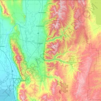
Naam: Topografische kaart Cache County, hoogte, reliëf.
Locatie: Cache County, Utah, VS (41.36891 -112.16450 41.99952 -111.39981)
Gemiddelde hoogte: 1.906 m
Minimale hoogte: 1.279 m
Maximale hoogte: 3.003 m
Andere topografische kaarten
Klik op een kaart om zijn topografie, zijn hoogte en zijn reliëf te bekijken.
Bryce Canyon National Park
Bryce Canyon National Park, Under the Rim Trail, Garfield County, Utah, VS
Gemiddelde hoogte: 2.259 m
Zion National Park
Zion National Park, West Rim Trail, Washington County, Utah, VS
Gemiddelde hoogte: 1.877 m
Capitol Reef National Park
Capitol Reef National Park, Notom To Oak Creek Road, Garfield County, Utah, VS
Gemiddelde hoogte: 1.963 m
Canyonlands National Park
Canyonlands National Park, Wayne County, Utah, VS
Gemiddelde hoogte: 1.640 m