
Topografische kaart Tramway Highpoint (HOA)
Interactieve kaart
Klik op de kaart om de hoogte weer te geven.
Over deze kaart
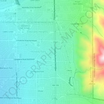
Naam: Topografische kaart Tramway Highpoint (HOA), hoogte, reliëf.
Gemiddelde hoogte: 1.822 m
Minimale hoogte: 1.686 m
Maximale hoogte: 2.322 m
Andere topografische kaarten
Klik op een kaart om zijn topografie, zijn hoogte en zijn reliëf te bekijken.
Sandia Heights
United States > New Mexico > Bernalillo County > Albuquerque
Sandia Heights, Albuquerque, Bernalillo County, New Mexico, 87111, United States
Gemiddelde hoogte: 1.898 m
Albuquerque
United States > New Mexico > Bernalillo County > Albuquerque
Albuquerque, Bernalillo County, New Mexico, 87102, United States
Gemiddelde hoogte: 1.671 m
Glenwood Hills
United States > New Mexico > Bernalillo County > Albuquerque
Glenwood Hills, Albuquerque, Bernalillo County, New Mexico, 87111, United States
Gemiddelde hoogte: 1.937 m
Joe M. Lucero Hillside
United States > New Mexico > Bernalillo County > Albuquerque
Joe M. Lucero Hillside, Albuquerque, Bernalillo County, New Mexico, United States
Gemiddelde hoogte: 1.637 m
Oso Grande
United States > New Mexico > Bernalillo County > Albuquerque
Oso Grande, Albuquerque, Bernalillo County, New Mexico, 87111, United States
Gemiddelde hoogte: 1.736 m