
Topografische kaart Pink
Interactieve kaart
Klik op de kaart om de hoogte weer te geven.
Over deze kaart
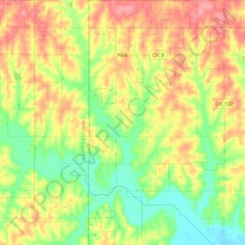
Naam: Topografische kaart Pink, hoogte, reliëf.
Locatie: Pink, Pottawatomie County, Oklahoma, United States (35.15967 -97.14222 35.28971 -97.05342)
Gemiddelde hoogte: 324 m
Minimale hoogte: 285 m
Maximale hoogte: 370 m
The 1891 Oklahoma and Indian Territories map portrays Shawneetown (Shawnee) as the only settlement north of Little River in the future Pottawatomie County. Pink appears later on Cram's 1898 Oklahoma and Indian Territory Map.] Topographic mapping of Pink and Pottawatomie County began sometime after 1903. Pink School was built sometime prior to its depiction on the 1910 McComb Quadrangle at the northwest corner of Section 28, Brinton Township (now corner of Okay Rd and Willow View Rd).