
Doe een donatie
Rust jezelf uit voor je volgende avontuur:
Als Amazon-partner verdient deze site een commissie op in aanmerking komende aankopen, zonder extra kosten voor jou.
Topografische kaart Bauschlott
Klik op de kaart om de hoogte weer te geven.
Doe een donatie
Rust jezelf uit voor je volgende avontuur:
Als Amazon-partner verdient deze site een commissie op in aanmerking komende aankopen, zonder extra kosten voor jou.
Over deze kaart
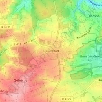
Naam: Topografische kaart Bauschlott, hoogte, reliëf.
Gemiddelde hoogte: 309 m
Minimale hoogte: 239 m
Maximale hoogte: 368 m
Doe een donatie
Rust jezelf uit voor je volgende avontuur:
Als Amazon-partner verdient deze site een commissie op in aanmerking komende aankopen, zonder extra kosten voor jou.
Andere topografische kaarten
Klik op een kaart om zijn topografie, zijn hoogte en zijn reliëf te bekijken.
Tiefenbronn
Germany > Baden-Württemberg > Enzkreis
The municipality (Gemeinde) of Tiefenbronn covers 14.79 square kilometers (5.71 sq mi) of the Enzkreis, a district of Baden-Württemberg, Germany. It is located on the edge of the Black Forest and the Upper Gäu [de]. The buntsandstein of the Röt Formation, under the Black Forest, extends into the municipal…
Gemiddelde hoogte: 448 m
Neuenbürg
Germany > Baden-Württemberg > Enzkreis
The township (Stadt) of Neuenbürg covers 28.17 square kilometers (10.88 sq mi) of the Enz district, within the state of Baden-Württemberg and the Federal Republic of Germany. It is physically located on the Pfinzhügelland [de], on the southern reaches of the Kraichgau. The geological makeup of the municipal…
Gemiddelde hoogte: 518 m
Doe een donatie
Rust jezelf uit voor je volgende avontuur:
Als Amazon-partner verdient deze site een commissie op in aanmerking komende aankopen, zonder extra kosten voor jou.
Wimsheim
Germany > Baden-Württemberg > Enzkreis
The municipality (Gemeinde) of Wimsheim covers 8.06 square kilometers (3.11 sq mi) of the Enz district of Baden-Württemberg, a state of the Federal Republic of Germany. Wimsheim is located in the metropolitan areas of Pforzheim and Karlsruhe and on the edge of the Black Forest, the Neckar basin [de], and the…
Gemiddelde hoogte: 438 m
Doe een donatie
Rust jezelf uit voor je volgende avontuur:
Als Amazon-partner verdient deze site een commissie op in aanmerking komende aankopen, zonder extra kosten voor jou.
Wiernsheim
Germany > Baden-Württemberg > Enzkreis
The municipality (Gemeinde) of Wiernsheim covers 24.62 kilometers (15.30 mi) of the Enzkreis, a district of the state of Baden-Württemberg and the Federal Republic of Germany. It is located in the metropolitan areas of Karlsruhe and Pforzheim, along the southwestern edge of the Neckar basin [de]. Wiernsheim…
Gemiddelde hoogte: 358 m
Illingen
Germany > Baden-Württemberg > Enzkreis
The municipality (Gemeinde) of Illingen is located at the eastern edge of the Enzkreis district, within the state of Baden-Württemberg and Federal Republic of Germany. It covers an area of 29.36 square kilometers (11.34 sq mi) that lies within the metropolitan areas of Karlsruhe and Pforzheim. Illingen is…
Gemiddelde hoogte: 279 m
Heimsheim
Germany > Baden-Württemberg > Enzkreis
The township (Stadt) Heimsheim covers an area of 14.3 square kilometers (5.5 sq mi) at the very southeastern tip of the Enz district. It is physically located in the foothills of the Black Forest, in the Heckengäu, a region geology is characterized by karstified and wooded muschelkalk hills. Because the…
Gemiddelde hoogte: 450 m
Doe een donatie
Rust jezelf uit voor je volgende avontuur:
Als Amazon-partner verdient deze site een commissie op in aanmerking komende aankopen, zonder extra kosten voor jou.