
Topografische kaart Swift Trail Junction
Interactieve kaart
Klik op de kaart om de hoogte weer te geven.
Over deze kaart
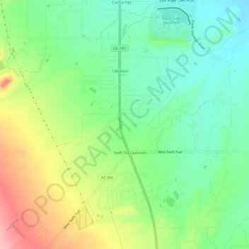
Naam: Topografische kaart Swift Trail Junction, hoogte, reliëf.
Gemiddelde hoogte: 984 m
Minimale hoogte: 932 m
Maximale hoogte: 1.073 m
Swift Trail Junction is a census-designated place (CDP) in Graham County, Arizona, United States. The population was 2,935 at the 2010 census, up from 2,195 in 2000. It is part of the Safford Micropolitan Statistical Area. It is situated at the junction of U.S. Route 191 and State Route 366 (also known as the Swift Trail Parkway). The Swift Trail Parkway is a scenic highway that winds through the Coronado National Forest and provides access to the higher elevations of the Pinaleño Mountains, also known as the Graham Mountains.
Andere topografische kaarten
Klik op een kaart om zijn topografie, zijn hoogte en zijn reliëf te bekijken.
Eden
United States > Arizona > Graham County
Eden, Graham County, Arizona, 85535, United States
Gemiddelde hoogte: 850 m
Thatcher
United States > Arizona > Graham County
Thatcher, Graham County, Arizona, 85552, United States
Gemiddelde hoogte: 912 m
Artesia
United States > Arizona > Graham County
Artesia, Graham County, Arizona, United States
Gemiddelde hoogte: 1.018 m
Mount Graham
United States > Arizona > Graham County
Mount Graham, Graham County, Arizona, United States
Gemiddelde hoogte: 2.957 m
Safford
United States > Arizona > Graham County
Safford, Graham County, Arizona, United States
Gemiddelde hoogte: 912 m
Safford
United States > Arizona > Graham County > Safford
Safford, Graham County, Arizona, 85548, United States
Gemiddelde hoogte: 1.113 m
Thumb Butte
United States > Arizona > Graham County
Thumb Butte, Graham County, Arizona, United States
Gemiddelde hoogte: 1.481 m
Quartzite Mountain
United States > Arizona > Graham County
Quartzite Mountain, Graham County, Arizona, United States
Gemiddelde hoogte: 1.574 m